File:1794 Anville Map of the Eastern Roman Empire (inclues Greece) - Geographicus - RomanEmpireEast-anville-1794.jpg

Size of this preview: 482 × 600 pixels. Other resolutions: 193 × 240 pixels | 386 × 480 pixels | 617 × 768 pixels | 823 × 1,024 pixels | 1,646 × 2,048 pixels | 4,019 × 5,000 pixels.
Original file (4,019 × 5,000 pixels, file size: 6.02 MB, MIME type: image/jpeg)
Captions
Captions
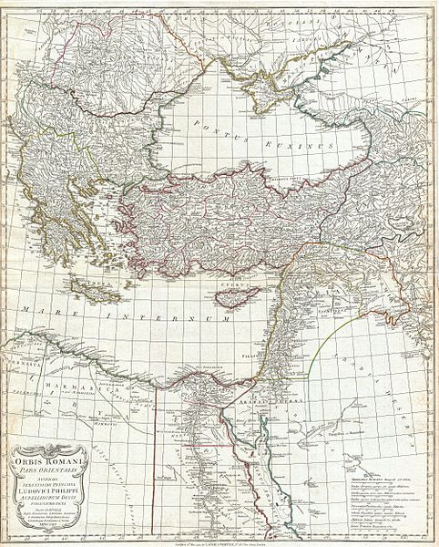
Eastern part of the Roman World under Prince Louis Philip of Aurelian
Summary edit
| Jean Baptiste Bourguignon d'Anville: Orbis Romani Pars Orientalis Auspiciis Serenissimi Principis Ludovici Philippi Aurelianorum Ducis Publici juris Facta…
( |
|||||||||||||||||||||
|---|---|---|---|---|---|---|---|---|---|---|---|---|---|---|---|---|---|---|---|---|---|
| Artist |
|
||||||||||||||||||||
| Title |
Orbis Romani Pars Orientalis Auspiciis Serenissimi Principis Ludovici Philippi Aurelianorum Ducis Publici juris Facta… |
||||||||||||||||||||
| Description |
English: A large and dramatic J. B. B. D'Anville map of the eastern part of the Roman Empire. Covers from Greece (Graecia) and Dacia east as far as Babylonia, Arabia and Armenia. Extends south as far as Thebes in Upper Egypt. Includes the eastern part of the Mediterranean (Mare Internum) and the Black Sea (Pontus Euxinus). Details mountains rivers, cities, roadways, and lakes with political divisions highlighted in outline color. Decorative title cartouche bearing the Roman Eagle appears in the lower left quadrant. Includes eight distance scales, bottom right, referencing various measurement systems common in antiquity. Text in Latin and English. Drawn by J. B. B. D'Anville in 1764 and published in 1794 by Laurie and Whittle, London. |
||||||||||||||||||||
| Date | dated 1764, published 1794 | ||||||||||||||||||||
| Dimensions | height: 26.5 in (67.3 cm); width: 21.5 in (54.6 cm) | ||||||||||||||||||||
| Accession number |
Geographicus link: RomanEmpireEast-anville-1794 |
||||||||||||||||||||
| Source/Photographer |
D'Anville, J. B. B., Complete Body of Ancient Geography, Laurie and Whittle, London, 1795.
|
||||||||||||||||||||
| Permission (Reusing this file) |
|
||||||||||||||||||||

_-_Geographicus_-_RomanEmpireEast-anville-1794.jpg&action=edit§ion=1)
Licensing edit
_-_Geographicus_-_RomanEmpireEast-anville-1794.jpg&action=edit§ion=2)
|
This is a faithful photographic reproduction of a two-dimensional, public domain work of art. The work of art itself is in the public domain for the following reason:
The official position taken by the Wikimedia Foundation is that "faithful reproductions of two-dimensional public domain works of art are public domain".
This photographic reproduction is therefore also considered to be in the public domain in the United States. In other jurisdictions, re-use of this content may be restricted; see Reuse of PD-Art photographs for details. | ||||
File history
Click on a date/time to view the file as it appeared at that time.
| Date/Time | Thumbnail | Dimensions | User | Comment | |
|---|---|---|---|---|---|
| current | 14:09, 23 March 2011 | | 4,019 × 5,000 (6.02 MB) | BotMultichillT (talk | contribs) | {{subst:User:Multichill/Geographicus |link=http://www.geographicus.com/P/AntiqueMap/RomanEmpireEast-anville-1794 |product_name=1794 Anville Map of the Eastern Roman Empire (inclues Greece) |map_title=Orbis Romani Pars Orientalis Auspiciis Serenissimi Prin |
You cannot overwrite this file.
File usage on Commons
The following page uses this file:
_-_Geographicus_-_RomanEmpireEast-anville-1794.jpg)
_-_Geographicus_-_RomanEmpireEast-anville-1794.jpg&oldid=803192365)