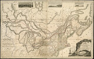
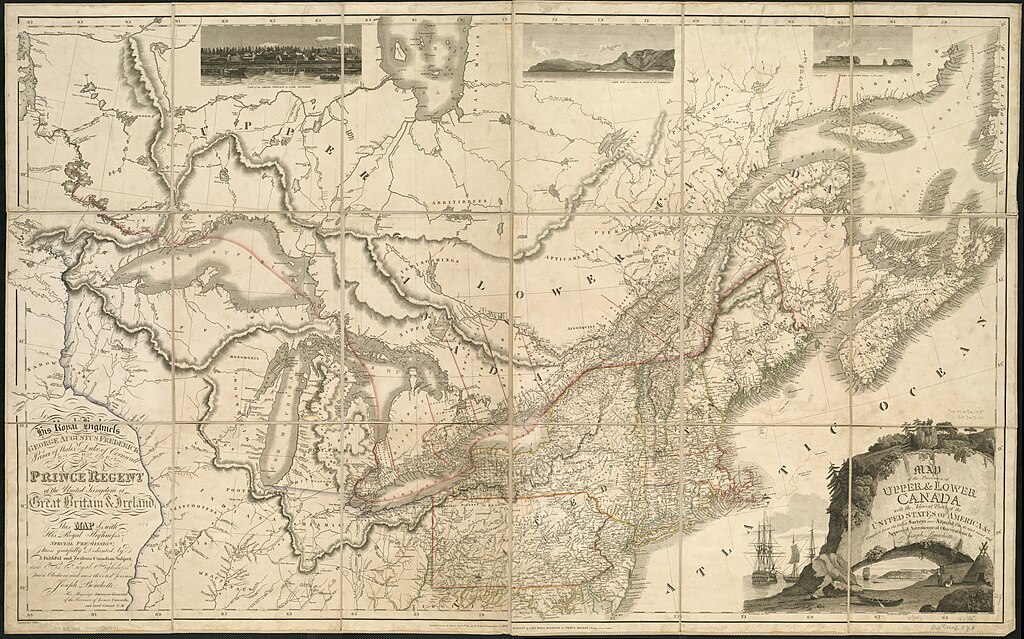
File:1815 Map of the provinces of upper & lower Canada with the adjacent parts of the United States of America, &c, by Joseph Bouchette, William Faden, J. Walker, from the Digital Commonwealth - commonwealth 8049g898c.jpg

Size of this preview: 800 × 500 pixels. Other resolutions: 320 × 200 pixels | 640 × 400 pixels | 1,024 × 639 pixels | 1,280 × 799 pixels | 2,560 × 1,599 pixels | 12,096 × 7,553 pixels.
Original file (12,096 × 7,553 pixels, file size: 104.56 MB, MIME type: image/jpeg)
Captions
Captions
Add a one-line explanation of what this file represents
Summary
edit
| Warning | The original file is very high-resolution. It might not load properly or could cause your browser to freeze when opened at full size. |
|---|
| Description |
English: 1815 Map of the provinces of upper & lower Canada with the adjacent parts of the United States of America, &c, by Joseph Bouchette, William Faden, J. Walker, from the Digital Commonwealth - commonwealth 8049g898c. (https://www.digitalcommonwealth.org/search/commonwealth:8049g898c) |
| Date | |
| Source | Digital Commonwealth |
| Author | Joseph Bouchette, William Faden, J. Walker |
Licensing
edit
|
This work is in the public domain in its country of origin and other countries and areas where the copyright term is the author's life plus 70 years or fewer. This work is in the public domain in the United States because it was published (or registered with the U.S. Copyright Office) before January 1, 1929. | |
| This file has been identified as being free of known restrictions under copyright law, including all related and neighboring rights. | |
File history
Click on a date/time to view the file as it appeared at that time.
| Date/Time | Thumbnail | Dimensions | User | Comment | |
|---|---|---|---|---|---|
| current | 20:50, 6 December 2021 | | 12,096 × 7,553 (104.56 MB) | Daderot (talk | contribs) | Uploaded a work by Joseph Bouchette, William Faden, J. Walker from Digital Commonwealth with UploadWizard |
You cannot overwrite this file.
File usage on Commons
There are no pages that use this file.