File:1845 trailmap.png
(Redirected from File:1845 trailmap.gif)

Size of this preview: 800 × 475 pixels. Other resolutions: 320 × 190 pixels | 640 × 380 pixels | 993 × 589 pixels.
Original file (993 × 589 pixels, file size: 37 KB, MIME type: image/png)
Captions
Captions
Add a one-line explanation of what this file represents
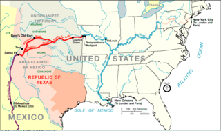
| Description | Santa Fe Trail around 1845 plus connecting trading routes to commercial hubs and ports in the USA | |||
| Source | http://www.nps.gov/beol/trailmap.gif | |||
| Author | NPS-graphics | |||
| Permission (Reusing this file) |
|
Original upload log
edit
| Date/Time | Dimensions | User | Comment |
|---|---|---|---|
| 26 July 2006, 11:15:24 | 993 × 589 (44064 bytes) | H-stt (talk · contribs) | {{Information |Description= Santa Fe Trail around 1845 plus connecting trading routes to ports in the USA |Source= http://www.nps.gov/beol/trailmap.gif |Date= |Author= NPS-graphics |Permission= {{PD-USGov-NPS}} |other_versions= }} [[Category:Santa Fe Nat |
File history
Click on a date/time to view the file as it appeared at that time.
| Date/Time | Thumbnail | Dimensions | User | Comment | |
|---|---|---|---|---|---|
| current | 16:42, 12 July 2014 | | 993 × 589 (37 KB) | GifTagger (talk | contribs) | Bot: Converting file to superior PNG file. (Source: 1845_trailmap.gif). This GIF was problematic due to non-greyscale color table. |
You cannot overwrite this file.
File usage on Commons
The following 2 pages use this file:
- Commons:Files used on the AARoads Wiki/1
- File:1845 trailmap.gif (file redirect)
File usage on other wikis
The following other wikis use this file:
- Usage on ca.wikipedia.org
- Usage on de.wikipedia.org
- Usage on en.wikipedia.org
- Usage on es.wikipedia.org
- Usage on fa.wikipedia.org
- Usage on fi.wikipedia.org
- Usage on fr.wikipedia.org
- Usage on hu.wikipedia.org
- Usage on it.wikipedia.org
- Usage on ja.wikipedia.org
- Usage on nl.wikipedia.org
- Usage on pl.wikipedia.org
- Usage on ru.wikipedia.org
- Usage on www.wikidata.org