File:1887 Map of Chicago and Environs by Blanchard.jpg

Original file (9,360 × 12,541 pixels, file size: 22.96 MB, MIME type: image/jpeg)
Captions
Captions
| Warning | The original file is very high-resolution. It might not load properly or could cause your browser to freeze when opened at full size. |
|---|
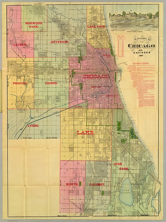
| Title |
Map of Chicago and Suburbs, Showing the Parks, Boulevards, Streets, Railroads, Horse Car Lines, etc. |
||||
| Description |
English: 1887 map of Chicago and Suburbs |
||||
| Date | |||||
| Source | David Rumsey Maps | ||||
| Creator |
Rufus Blanchard, with National School Furnishing Co. |
||||
| Permission (Reusing this file) |
|
||||
| Geotemporal data | |||||
| Date depicted | |||||
| Map location | Chicago | ||||
| Georeferencing | If inappropriate please set warp_status = skip to hide. | ||||
| Bibliographic data | |||||
| Printed by |
141 and 143 Wabash Avenue, Chicago |
||||
File history
Click on a date/time to view the file as it appeared at that time.
| Date/Time | Thumbnail | Dimensions | User | Comment | |
|---|---|---|---|---|---|
| current | 18:56, 25 February 2016 | | 9,360 × 12,541 (22.96 MB) | Scewing (talk | contribs) | {{LargeImage}} {{Map |title = Map of Chicago and Suburbs, Showing the Parks, Boulevards, Streets, Railroads, Horse Car Lines, etc. |description = {{en|1887 map of Chicago and Suburbs}} |legend = |author = Rufus... |
You cannot overwrite this file.
File usage on Commons
There are no pages that use this file.