File:1893 Plan Arys.jpg

Size of this preview: 507 × 600 pixels. Other resolutions: 203 × 240 pixels | 406 × 480 pixels | 649 × 768 pixels | 866 × 1,024 pixels | 2,253 × 2,665 pixels.
Original file (2,253 × 2,665 pixels, file size: 1.49 MB, MIME type: image/jpeg)
Captions
Captions
Add a one-line explanation of what this file represents
Summary
edit
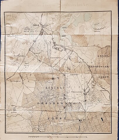
| Description | Manöver Plan des Truppenübungsplatzes Arys von 1893, Ostpreußen |
| Date | Taken in 16 March 2019 |
| Source | Archiv Michael Musto |
| Author | Michael Musto |
| Permission (Reusing this file) |
Own work |
| Camera location | | View this and other nearby images on: OpenStreetMap |
|---|
I, the copyright holder of this work, hereby publish it under the following license:
This file is licensed under the Creative Commons Attribution-Share Alike 4.0 International license.
- You are free:
- to share – to copy, distribute and transmit the work
- to remix – to adapt the work
- Under the following conditions:
- attribution – You must give appropriate credit, provide a link to the license, and indicate if changes were made. You may do so in any reasonable manner, but not in any way that suggests the licensor endorses you or your use.
- share alike – If you remix, transform, or build upon the material, you must distribute your contributions under the same or compatible license as the original.
File history
Click on a date/time to view the file as it appeared at that time.
| Date/Time | Thumbnail | Dimensions | User | Comment | |
|---|---|---|---|---|---|
| current | 18:06, 10 March 2021 | | 2,253 × 2,665 (1.49 MB) | Michael Musto (talk | contribs) | {{Information |Description= Manöver Plan des Truppenübungsplatzes Arys von 1893, Ostpreußen |Source={{own}} |Date={{taken in|2019-03-16}} |Author=Photo: Michael Musto |Permission={{own}} |other_versions= }} {{self|cc-by-sa-4.0}} Category:Proving ground Orzysz (before 1945) Category:1893 documents |
You cannot overwrite this file.
File usage on Commons
There are no pages that use this file.
File usage on other wikis
The following other wikis use this file:
- Usage on de.wikipedia.org