File:19-26-266-sign.jpg

Original file (4,096 × 2,584 pixels, file size: 1.93 MB, MIME type: image/jpeg)
Captions
Captions
Summary edit
| Description |
English:
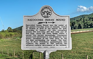
Nacoochee Indian Mound Nacoochee Indian Mound was the center of the ancient Cherokee town of Gauxule, visited by DeSoto in 1540 in his search for gold, according to legend. On this ceremonial mound, 190 feet long, 150 feet wide and 20 feet high, stood the Town House where a sacred fire burned unceasingly. Ceremonial dances were performed in and around the Town House. Residents of the town lived on the flat land surrounding the mound. The findings of Heye Foundation archaeologists who explored the mound in 1915 indicate the advanced cultural development of the builders. |
| Date | |
| Source | Own work |
| Author | Dsdugan |
| Camera location | | View this and other nearby images on: OpenStreetMap |
|---|
Licensing edit
| This file is made available under the Creative Commons CC0 1.0 Universal Public Domain Dedication. | |
| The person who associated a work with this deed has dedicated the work to the public domain by waiving all of their rights to the work worldwide under copyright law, including all related and neighboring rights, to the extent allowed by law. You can copy, modify, distribute and perform the work, even for commercial purposes, all without asking permission.
|
File history
Click on a date/time to view the file as it appeared at that time.
| Date/Time | Thumbnail | Dimensions | User | Comment | |
|---|---|---|---|---|---|
| current | 17:17, 8 June 2022 | | 4,096 × 2,584 (1.93 MB) | Dsdugan (talk | contribs) | color image |
| 21:07, 9 September 2020 |  | 3,634 × 2,602 (2 MB) | Dsdugan (talk | contribs) | Uploaded own work with UploadWizard |
You cannot overwrite this file.
File usage on Commons
There are no pages that use this file.
File usage on other wikis
The following other wikis use this file:
- Usage on en.wikipedia.org