File:1907BurkeCanyonIdaho geologicmap.png
Size of this preview: 800 × 395 pixels. Other resolutions: 320 × 158 pixels | 640 × 316 pixels | 1,024 × 506 pixels | 1,819 × 899 pixels.
Original file (1,819 × 899 pixels, file size: 4.72 MB, MIME type: image/png)
Captions
Captions
Add a one-line explanation of what this file represents
Summary edit
| Description |
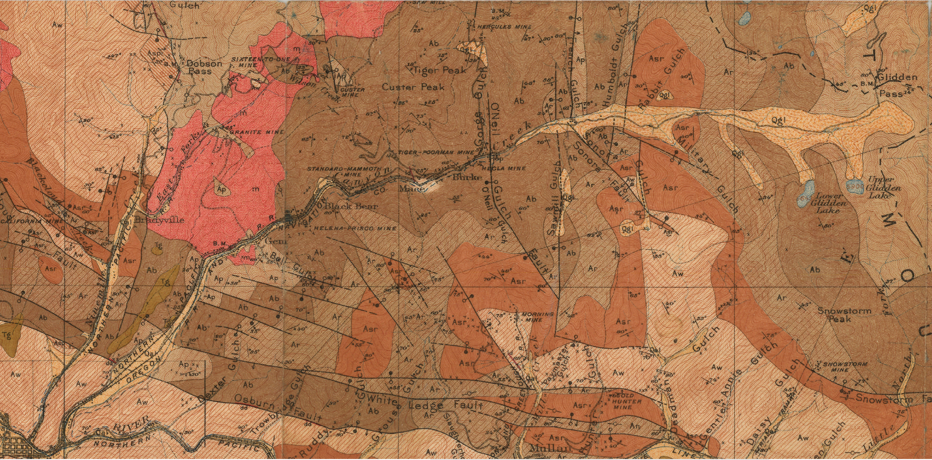
English: 1907 Burke Canyon Idaho geologic map, where m is monzonite and syenite, Ap is Prichard Slate, Ab is Burke Formation, Ar is Revett Quartzite, Asr is St. Regis Formation, Aw is Wallace Formation, Asp is Striped Peak Formation, Tg are Tertiary terrace gravels, Qgl is Quaternary glacial deposits, Qal is Quaternary alluvium, x is a prospect pit and y is a tunnel |
| Date | |
| Source | The geology and ore deposits of the Coeur d'Alene district, Idaho, USGS Professional Paper 62, https://pubs.er.usgs.gov/publication/pp62 |
| Author | U.S. Dept. of the Interior, USGS, F. L. Ransome and Frank Cathcart Calkins |
Licensing edit
This image is in the public domain in the United States because it only contains materials that originally came from the United States Geological Survey, an agency of the United States Department of the Interior. For more information, see the official USGS copyright policy.
|
File history
Click on a date/time to view the file as it appeared at that time.
| Date/Time | Thumbnail | Dimensions | User | Comment | |
|---|---|---|---|---|---|
| current | 17:24, 21 November 2018 | | 1,819 × 899 (4.72 MB) | Pi3.124 (talk | contribs) | User created page with UploadWizard |
You cannot overwrite this file.
File usage on Commons
There are no pages that use this file.
File usage on other wikis
The following other wikis use this file:
- Usage on en.wikipedia.org