File:1911Watling Street.png

Size of this preview: 800 × 521 pixels. Other resolutions: 320 × 209 pixels | 640 × 417 pixels | 1,024 × 667 pixels | 1,280 × 834 pixels | 2,016 × 1,314 pixels.
Original file (2,016 × 1,314 pixels, file size: 169 KB, MIME type: image/png)
Captions
Captions
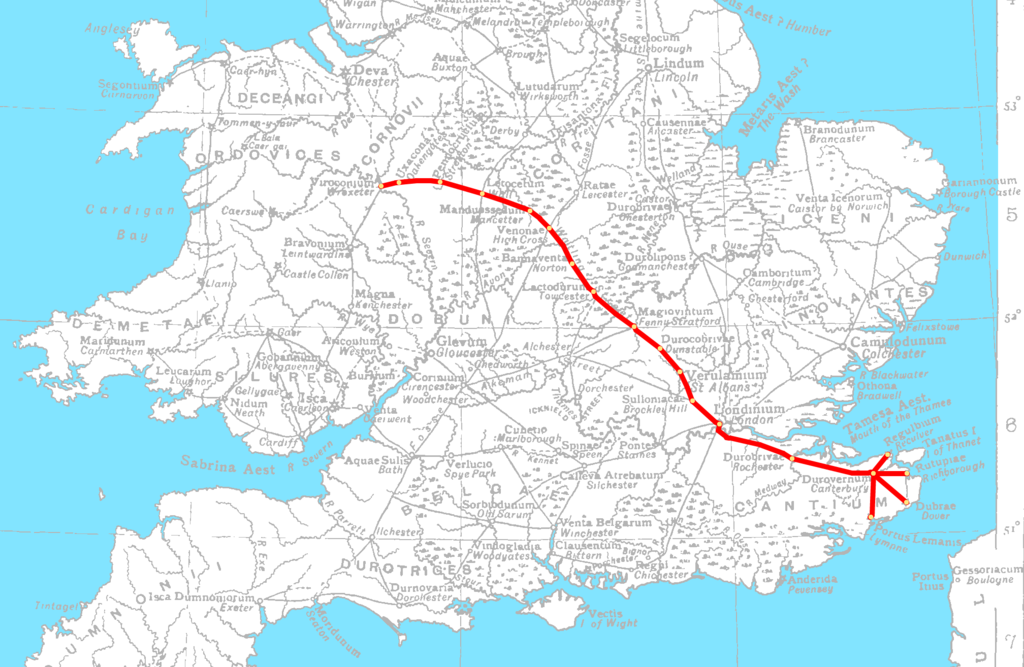
Route of Watling Street overlaid on map of Roman Britain
Summary
edit| Description |
English: A map of Watling Street overlaid on the 1911 Encyclopædia Britannica map of Roman Britain |
| Date | |
| Source | Own work |
| Author | LlywelynII |
| Other versions |
|


Licensing
edit
I, the copyright holder of this work, hereby publish it under the following license:
This file is licensed under the Creative Commons Attribution-Share Alike 4.0 International license.
- You are free:
- to share – to copy, distribute and transmit the work
- to remix – to adapt the work
- Under the following conditions:
- attribution – You must give appropriate credit, provide a link to the license, and indicate if changes were made. You may do so in any reasonable manner, but not in any way that suggests the licensor endorses you or your use.
- share alike – If you remix, transform, or build upon the material, you must distribute your contributions under the same or compatible license as the original.
File history
Click on a date/time to view the file as it appeared at that time.
| Date/Time | Thumbnail | Dimensions | User | Comment | |
|---|---|---|---|---|---|
| current | 16:23, 20 February 2015 | | 2,016 × 1,314 (169 KB) | LlywelynII (talk | contribs) | Clearer map |
| 14:55, 20 February 2015 |  | 1,474 × 1,006 (189 KB) | LlywelynII (talk | contribs) | User created page with UploadWizard |
You cannot overwrite this file.
File usage on Commons
The following 2 pages use this file:
File usage on other wikis
The following other wikis use this file:
- Usage on br.wikipedia.org
- Usage on ca.wikipedia.org
- Usage on cy.wikipedia.org
- Usage on en.wikipedia.org
- Usage on hr.wikipedia.org
- Usage on pl.wikipedia.org
- Usage on pt.wikipedia.org
- Usage on ru.wikipedia.org
- Usage on www.wikidata.org
- Usage on zh.wikipedia.org