File:1911 - Sketch map to shew approximately railways in Asiatic Turkey.jpg

Size of this preview: 800 × 567 pixels. Other resolutions: 320 × 227 pixels | 640 × 454 pixels | 1,024 × 726 pixels | 1,280 × 908 pixels | 2,560 × 1,815 pixels | 5,939 × 4,211 pixels.
Original file (5,939 × 4,211 pixels, file size: 3.02 MB, MIME type: image/jpeg)
Captions
Captions
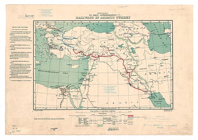
1911 map of the railways in Turkey in Asia by the British War Office
Summary
edit
| Description |
English: 1911 map of the railways in Turkey in Asia by the British War Office |
| Date | |
| Source | https://collections.lib.uwm.edu/digital/collection/agdm/id/17130/rec/1 |
| Author | Great Britain. War Office. General Staff. Topographical Section |
Licensing
edit
This work created by the United Kingdom Government is in the public domain.
This is because it is one of the following:
HMSO has declared that the expiry of Crown Copyrights applies worldwide (ref: HMSO Email Reply)
|
 |
File history
Click on a date/time to view the file as it appeared at that time.
| Date/Time | Thumbnail | Dimensions | User | Comment | |
|---|---|---|---|---|---|
| current | 17:01, 8 March 2019 | | 5,939 × 4,211 (3.02 MB) | Balkanique (talk | contribs) | User created page with UploadWizard |
You cannot overwrite this file.
File usage on Commons
The following 5 pages use this file:
File usage on other wikis
The following other wikis use this file:
- Usage on de.wikipedia.org