File:1915 USGS Topo Prosser.jpg

Size of this preview: 800 × 533 pixels. Other resolutions: 320 × 213 pixels | 640 × 427 pixels | 1,024 × 682 pixels | 1,526 × 1,017 pixels.
Original file (1,526 × 1,017 pixels, file size: 909 KB, MIME type: image/jpeg)
Captions
Captions
Add a one-line explanation of what this file represents
Summary edit
| Description |
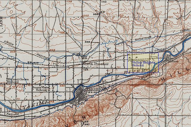
English: USGS 1:125,000 Topographical Map of Prosser, Washington (portion; modified for clarity to depict Valley Heights community) |
| Date | |
| Source | Courtesy of University of Washington Libraries |
| Author | United States Geological Survey |
Licensing edit
This image is in the public domain in the United States because it only contains materials that originally came from the United States Geological Survey, an agency of the United States Department of the Interior. For more information, see the official USGS copyright policy.
|
Original upload log edit
The original description page was here. All following user names refer to en.wikipedia.
| Date/Time | Dimensions | User | Comment |
|---|---|---|---|
| 2011-07-14 13:55 | 1526×1017× (930426 bytes) | MrX | {{Information | description = USGS 1:125,000 Topographical Map of Prosser, Washington (portion; modified for clarity to depict Valley Heights community) | source = Courtesy of University of Washington Libraries | date = 1915 | author = US |
File history
Click on a date/time to view the file as it appeared at that time.
| Date/Time | Thumbnail | Dimensions | User | Comment | |
|---|---|---|---|---|---|
| current | 19:12, 18 February 2017 | | 1,526 × 1,017 (909 KB) | Innotata (talk | contribs) | Transferred from en.wikipedia |
You cannot overwrite this file.
File usage on Commons
There are no pages that use this file.
File usage on other wikis
The following other wikis use this file:
- Usage on en.wikipedia.org