File:1924 anotações.jpg

Size of this preview: 800 × 512 pixels. Other resolutions: 320 × 205 pixels | 640 × 410 pixels | 1,024 × 655 pixels | 1,280 × 819 pixels | 1,820 × 1,165 pixels.
Original file (1,820 × 1,165 pixels, file size: 282 KB, MIME type: image/jpeg)
Captions
Captions
Add a one-line explanation of what this file represents
Summary edit
| Description |
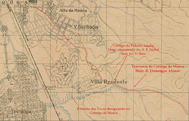
Português: : Parte do mapa de São Paulo no ano de 1924 com apontamentos em vermelho, mostrando o trajeto da Estrada do Oratório |
| Date | |
| Source | Mapa de São Paulo 1924 com apontamentos sobre a Estrada do Oratório |
| Author | Ricardo Domingues Pôssas |
Licensing edit
{{subst:apagar2}}
I, the copyright holder of this work, hereby publish it under the following license:
| This file is made available under the Creative Commons CC0 1.0 Universal Public Domain Dedication. | |
| The person who associated a work with this deed has dedicated the work to the public domain by waiving all of their rights to the work worldwide under copyright law, including all related and neighboring rights, to the extent allowed by law. You can copy, modify, distribute and perform the work, even for commercial purposes, all without asking permission.
|
File history
Click on a date/time to view the file as it appeared at that time.
| Date/Time | Thumbnail | Dimensions | User | Comment | |
|---|---|---|---|---|---|
| current | 18:32, 27 September 2019 | | 1,820 × 1,165 (282 KB) | Ricardo Domingues Pôssas (talk | contribs) | {{Information |description ={{pt-br|1=: Parte do mapa de São Paulo no ano de 1924 com apontamentos em vermelho, mostrando o trajeto da Estrada do Oratório}} {{pt-br|1=: Parte do mapa de São Paulo no ano de 1924 com apontamentos em vermelho, mostrando o trajeto da Estrada do Oratório}} |date =20/09/2019 |source =Mapa de São Paulo 1924 com apontamentos sobre a Estrada do Oratório |author =Ricardo Domingues Pôssas |permission =De acordo com a Lei do Direito Autoral Br... |
You cannot overwrite this file.
File usage on Commons
There are no pages that use this file.