File:1929 BERy system map.jpg

Size of this preview: 330 × 599 pixels. Other resolutions: 132 × 240 pixels | 264 × 480 pixels | 423 × 768 pixels | 564 × 1,024 pixels | 1,128 × 2,048 pixels | 2,711 × 4,920 pixels.
Original file (2,711 × 4,920 pixels, file size: 8.24 MB, MIME type: image/jpeg)
Captions
Captions
Add a one-line explanation of what this file represents
| Description |
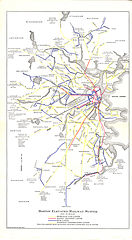
English: 1929 folder map of the Boston Elevated Railway. This map represents an intermediate stage between earlier minimalist maps showing only thin route lines, and later maps with thicker lines and more streets shown. The map dates between September 1928 when Shawmut and Ashmont opened, and August 1929 when the first section of the Ashmont-Mattapan High Speed Line opened. |
|||
| Date | ||||
| Source | Scanned map on flickr | |||
| Author | Boston Elevated Railway, via the Back Bay Electrotype Company | |||
| Permission (Reusing this file) |
|

File history
Click on a date/time to view the file as it appeared at that time.
| Date/Time | Thumbnail | Dimensions | User | Comment | |
|---|---|---|---|---|---|
| current | 15:10, 22 September 2013 | | 2,711 × 4,920 (8.24 MB) | Pi.1415926535 (talk | contribs) | {{Information |Description ={{en|1=1929 folder map of the Boston Elevated Railway. This map represents an intermediate stage between earlier minimalist maps showing only thin route lines, and later maps with thicker lines and more streets shown. The... |
You cannot overwrite this file.
File usage on Commons
There are no pages that use this file.