File:1937 map of La Porte County, Indiana (cartographic material) - prepared by John A. Kelley. - DPLA - c5fe182034118808f31b3cc2fe5e4ef9.jpg

Size of this preview: 461 × 599 pixels. Other resolutions: 185 × 240 pixels | 369 × 480 pixels | 591 × 768 pixels | 788 × 1,024 pixels | 1,576 × 2,048 pixels | 5,113 × 6,642 pixels.
Original file (5,113 × 6,642 pixels, file size: 4.48 MB, MIME type: image/jpeg)
Captions
Captions
Add a one-line explanation of what this file represents
Summary
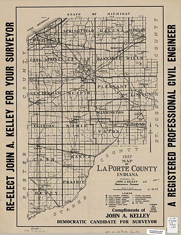
edit| 1937 map of La Porte County, Indiana [cartographic material] / prepared by John A. Kelley.
( |
|||||||||||||||||
|---|---|---|---|---|---|---|---|---|---|---|---|---|---|---|---|---|---|
| Creator | Kelley, John A., C.E | ||||||||||||||||
| Title |
1937 map of La Porte County, Indiana [cartographic material] / prepared by John A. Kelley. |
||||||||||||||||
| Description |
"Complements of John A. Kelley, Democratic candidate for Surveyor."; Scale [ca. 1:120,000]. |
||||||||||||||||
| Collection |
|
||||||||||||||||
| Source/Photographer |
|
||||||||||||||||
| Permission (Reusing this file) |
Copyright determination made by Indiana University Libraries ( Q58241552) using RightsStatements.org
|
||||||||||||||||


_-_prepared_by_John_A._Kelley._-_DPLA_-_c5fe182034118808f31b3cc2fe5e4ef9.jpg&action=edit§ion=1)
File history
Click on a date/time to view the file as it appeared at that time.
| Date/Time | Thumbnail | Dimensions | User | Comment | |
|---|---|---|---|---|---|
| current | 00:26, 9 April 2023 | | 5,113 × 6,642 (4.48 MB) | DPLA bot (talk | contribs) | Uploading DPLA ID dpla:c5fe182034118808f31b3cc2fe5e4ef9 |
You cannot overwrite this file.
File usage on Commons
The following page uses this file:
_-_prepared_by_John_A._Kelley._-_DPLA_-_c5fe182034118808f31b3cc2fe5e4ef9.jpg)
_-_prepared_by_John_A._Kelley._-_DPLA_-_c5fe182034118808f31b3cc2fe5e4ef9.jpg&oldid=882213676)