File:1948 Fukui Earthquake Fault on aerial photograph.png
Size of this preview: 399 × 599 pixels. Other resolutions: 160 × 240 pixels | 320 × 480 pixels | 512 × 768 pixels | 1,199 × 1,799 pixels.
Original file (1,199 × 1,799 pixels, file size: 2.3 MB, MIME type: image/png)
Captions
Captions
1948 Fukui Earthquake Fault on aerial photograph
Summary edit
| Description |
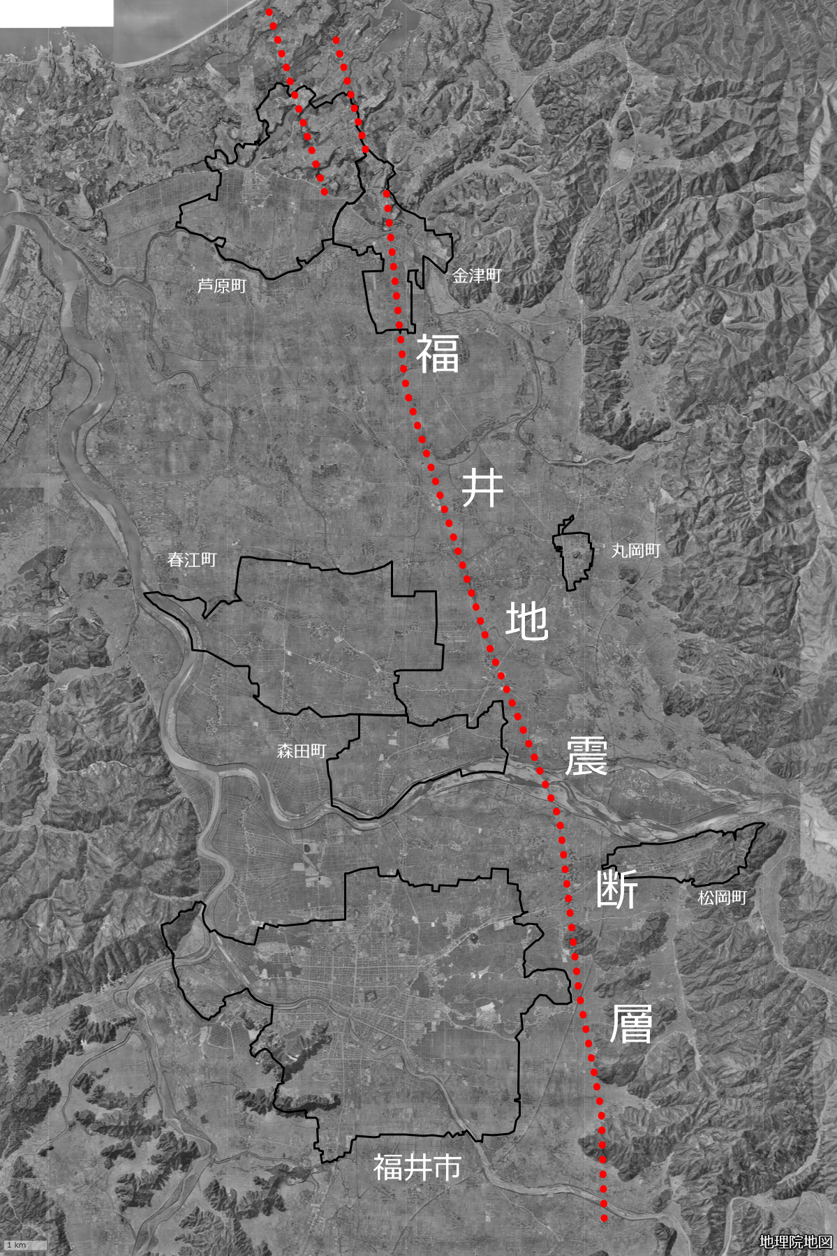
日本語: 1960年代の国土地理院空中写真と国土地理院の陰影起伏図を合成した地図に福井地震断層を赤い点線で示したもの。1948年福井地震の地震断層で、福井平野東縁断層帯の一部。
主な被災市町の1950年10月1日時点の行政区域(黒い線)も示した。
English: The 1948 Fukui Earthquake Fault, shown in red dotted line. This map is a composite of aerial photograph in the 1960s and hillshade map of the Geospatial Information Authority of Japan(GSI). Administrative border of damaged city and towns as of October 1, 1950 are also shown in black lines. |
| Date | |
| Source |
日本語: 地理院地図のwebビューアを利用して作成(作成時地図:[1])。Doraemonplusさんが作成していた地図を原案として、かつ断層・行政区域の出典を引用し作成。
|
| Author | Peka |
Licensing edit

|
This work is licensed under the Government of Japan Standard Terms of Use (Ver.2.0). The Terms of Use are compatible with the Creative Commons Attribution License 4.0 International. For the terms of use of this work, see this license page.
|
This file is licensed under the Creative Commons Attribution 4.0 International license.
Attribution: 国土地理院 (GSI)
- You are free:
- to share – to copy, distribute and transmit the work
- to remix – to adapt the work
- Under the following conditions:
- attribution – You must give appropriate credit, provide a link to the license, and indicate if changes were made. You may do so in any reasonable manner, but not in any way that suggests the licensor endorses you or your use.
File history
Click on a date/time to view the file as it appeared at that time.
| Date/Time | Thumbnail | Dimensions | User | Comment | |
|---|---|---|---|---|---|
| current | 15:57, 15 May 2023 | | 1,199 × 1,799 (2.3 MB) | Peka (talk | contribs) | Uploaded a work by Peka from {{ja|[https://maps.gsi.go.jp/ 地理院地図]のwebビューアを利用して作成。Doraemonplusさんが作成していた地図を原案として、かつ断層・行政区域の出典を引用し作成。 * 地図の使用タイルは国土地理院の[https://maps.gsi.go.jp/development/ichiran.html#ort_old10 空中写真(1961年~1969年)]と[https://maps.gsi.go.jp/development/ichiran.html#hillshademap 陰影起伏図]。 * 行政区域は国土交通省 [https://nlftp.mlit.go.jp/ksj/gml/datalist/KsjTmplt-N03-v3_0.html#prefecture18 国土数値情報 行政区域データ 福井県](1950年10月1日時点)による。 * 断層位置は[[:ja:地震調査研究推進本部|地震調査研究推進本部]... |
You cannot overwrite this file.
File usage on Commons
There are no pages that use this file.
File usage on other wikis
The following other wikis use this file:
- Usage on ja.wikipedia.org