File:1956 map of Hainan Island, People's Republic of China (cropped).jpg

Original file (3,663 × 3,510 pixels, file size: 2.43 MB, MIME type: image/jpeg)
Captions
Captions
| Warning | The original file is very high-resolution. It might not load properly or could cause your browser to freeze when opened at full size. |
|---|
Summary
edit| Description |
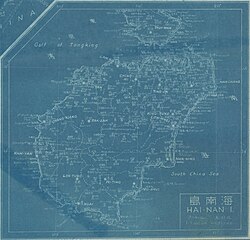
中文(繁體):廣東省(含廣州市、海南島)地圖。藏於澳洲國家圖書館。 |
| Date | |
| Source | http://nla.gov.au/nla.map-brsc104 |
| Author | C.H.I.D. |
| Other versions |

.jpg&flash=no)
.jpg&action=edit§ion=1)
Licensing
edit.jpg&action=edit§ion=2)
This image is now in the public domain in China because its term of copyright has expired. According to copyright laws of the People's Republic of China (with legal jurisdiction in the mainland only, excluding Hong Kong and Macao), amended November 11, 2020, Works of legal persons or organizations without legal personality, or service works, or audiovisual works, enter the public domain 50 years after they were first published, or if unpublished 50 years from creation. For photography works of natural persons whose copyright protection period expires before June 1, 2021 belong to the public domain. All other works of natural persons enter the public domain 50 years after the death of the creator. To uploader: Please provide where the image was first published and who created it or held its copyright.
|
  |
File history
Click on a date/time to view the file as it appeared at that time.
| Date/Time | Thumbnail | Dimensions | User | Comment | |
|---|---|---|---|---|---|
| current | 20:18, 9 February 2023 | | 3,663 × 3,510 (2.43 MB) | Ooligan (talk | contribs) | Cropped 6 % horizontally, 5 % vertically, rotated 0.7° using CropTool with precise mode. |
| 20:05, 9 February 2023 |  | 3,900 × 3,703 (2.85 MB) | Ooligan (talk | contribs) | File:Kwangtung Canton Hainan Island Map.jpg cropped 66 % horizontally, 56 % vertically using CropTool with lossless mode. |
You cannot overwrite this file.
File usage on Commons
The following page uses this file:
.jpg&oldid=747493863)