File:1964 Alaska Quake Penney Bldg.jpg

Size of this preview: 800 × 531 pixels. Other resolutions: 320 × 212 pixels | 640 × 425 pixels | 1,024 × 679 pixels | 1,280 × 849 pixels | 2,560 × 1,698 pixels | 3,582 × 2,376 pixels.
Original file (3,582 × 2,376 pixels, file size: 3.11 MB, MIME type: image/jpeg)
Captions
Captions
Add a one-line explanation of what this file represents
Summary
edit
| Description |
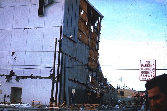
English: Two artifacts of the history of Anchorage, Alaska are found in this photo taken following the 1964 Alaska earthquake. In the foreground is the original Penney Building in Anchorage. Built in 1962 as a five-story structure, containing nearly 100,000 square feet. The building collapsed in the shaking, centered around its northeast corner and its north and east walls. The building was torn down to its foundation, and in its place was built a three-story building on a larger footprint on the same site. Directly across Fifth Avenue is the Club Rendezvous. The building shows evidence of slight damage, but is still functional. The building burned down in 1970, and despite its prime location in Anchorage's central business district, nothing was ever built on the lot to replace it. In recent years, it has been used as an outdoor seating area for a salmon bake restaurant. UPDATE: I think I snapped a few photos on this corner last summer. The salmon bake was gone. A tent retailer set up shop on the lot where the Rendezvous stood.RadioKAOS (talk) 17:47, 24 April 2014 (UTC) |
| Date | |
| Source | http://libraryphoto.cr.usgs.gov/cgi-bin/show_picture.cgi?ID=ID.%20Alaska%20Earthquake%20no.%20%20%20%2023ct&SIZE=large Web page includes photo description |
| Author | Unknown author |
| Camera location | | View this and other nearby images on: OpenStreetMap |
|---|
Licensing
edit
This image is in the public domain in the United States because it only contains materials that originally came from the United States Geological Survey, an agency of the United States Department of the Interior. For more information, see the official USGS copyright policy.
|
File history
Click on a date/time to view the file as it appeared at that time.
| Date/Time | Thumbnail | Dimensions | User | Comment | |
|---|---|---|---|---|---|
| current | 06:30, 3 December 2010 | | 3,582 × 2,376 (3.11 MB) | RadioKAOS (talk | contribs) | {{Information |Description={{en|1=Two artifacts of the history of Anchorage, Alaska are found in this photo taken following the 1964 Alaska earthquake. In the foreground is the original Penney Building in Anchorage. Built in 1962 as a five-story structu |
You cannot overwrite this file.
File usage on Commons
There are no pages that use this file.
File usage on other wikis
The following other wikis use this file:
- Usage on en.wikipedia.org
- Usage on id.wikipedia.org
- Usage on it.wikipedia.org
- Usage on ko.wikipedia.org