File:1990 Manjil–Rudbar earthquake shakemap.jpg

Size of this preview: 486 × 600 pixels. Other resolutions: 194 × 240 pixels | 389 × 480 pixels | 787 × 971 pixels.
Original file (787 × 971 pixels, file size: 401 KB, MIME type: image/jpeg)
Captions
Captions
Add a one-line explanation of what this file represents
Summary edit
| Description |
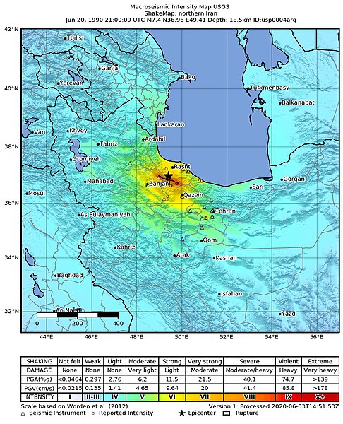
English: USGS shakemap of the 1990 Manjil–Rudbar earthquake
Deutsch: Shakemap des Manjil-Rudbar-Erdbebens vom 21. Juni 1990 (Ortszeit) |
|||
| Date | ||||
| Source | https://earthquake.usgs.gov/earthquakes/eventpage/iscgem366754/shakemap/intensity | |||
| Author | United States Geological Survey | |||
| Permission (Reusing this file) |
|
File history
Click on a date/time to view the file as it appeared at that time.
| Date/Time | Thumbnail | Dimensions | User | Comment | |
|---|---|---|---|---|---|
| current | 09:11, 15 October 2020 | | 787 × 971 (401 KB) | IllCom (talk | contribs) | {{Information |description ={{en|1=USGS shakemap of the 1990 Manjil–Rudbar earthquake}} {{de|1=Shakemap des Manjil-Rudbar-Erdbebens vom 21. Juni 1990 (Ortszeit)}} |date =2020-06-03 |source =https://earthquake.usgs.gov/earthquakes/eventpage/iscgem366754/shakemap/intensity |author =United States Geological Survey |permission ={{PD-USGov-USGS}} }} Category:ShakeMaps of earthquakes in Iran Category:1990 Manjil–Rudbar earthquake |
You cannot overwrite this file.
File usage on Commons
There are no pages that use this file.
File usage on other wikis
The following other wikis use this file:
- Usage on de.wikipedia.org
- Usage on en.wikipedia.org
- Usage on id.wikipedia.org