File:2008-11-26 Damawand Inflight Panorama.jpg

Size of this preview: 800 × 281 pixels. Other resolutions: 320 × 112 pixels | 640 × 224 pixels | 1,024 × 359 pixels | 1,280 × 449 pixels | 4,064 × 1,425 pixels.
Original file (4,064 × 1,425 pixels, file size: 1.34 MB, MIME type: image/jpeg)
Captions
Captions
Add a one-line explanation of what this file represents
| Description |
|
||
| Date | Taken on 26 November 2008, 04:28:34 | ||
| Source |
Own work of Simisa (talk · contribs)
|
||
| Author | Hansueli Krapf | ||
| Permission (Reusing this file) |
Attribution ShareAlike 3.0 |

| Camera location | | View this and other nearby images on: OpenStreetMap |
|---|
This file is licensed under the Creative Commons Attribution-Share Alike 3.0 Unported license.
- You are free:
- to share – to copy, distribute and transmit the work
- to remix – to adapt the work
- Under the following conditions:
- attribution – You must give appropriate credit, provide a link to the license, and indicate if changes were made. You may do so in any reasonable manner, but not in any way that suggests the licensor endorses you or your use.
- share alike – If you remix, transform, or build upon the material, you must distribute your contributions under the same or compatible license as the original.
| Annotations | This image is annotated: View the annotations at Commons |
File history
Click on a date/time to view the file as it appeared at that time.
| Date/Time | Thumbnail | Dimensions | User | Comment | |
|---|---|---|---|---|---|
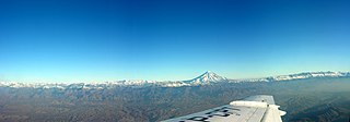
| current | 11:57, 12 July 2009 | 4,064 × 1,425 (1.34 MB) | Simisa (talk | contribs) | {{Information |Description={{IRN}}, In-flight panorama of Damavand |Source={{Own}} of {{User|Simisa}} {{Panorama|category=}} |Date=see metadata |Author=Hansueli Krapf |Permission=Attribution ShareAlike 3.0 |other_versions= }} {{cc-by-sa- |
You cannot overwrite this file.
File usage on Commons
There are no pages that use this file.
File usage on other wikis
The following other wikis use this file:
- Usage on azb.wikipedia.org
- Usage on de.wikipedia.org
- Usage on en.wikiversity.org
- Usage on fa.wikipedia.org
- Usage on he.wikipedia.org
- Usage on sl.wikipedia.org