File:2008 Atlantic hurricane season map.png

Size of this preview: 776 × 600 pixels. Other resolutions: 311 × 240 pixels | 621 × 480 pixels | 994 × 768 pixels | 1,320 × 1,020 pixels.
Original file (1,320 × 1,020 pixels, file size: 1.26 MB, MIME type: image/png)
Captions
Captions
Add a one-line explanation of what this file represents
Summary edit
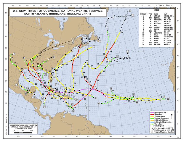
| Description | Season summary provided by NOAA of the 2008 Atlantic hurricane season. |
| Date | Unknown, most likely the year of the season. |
| Source | Originally from http://www.nhc.noaa.gov/tracks/ |
| Author | National Hurricane Center |
- For usage instructions and information about updating this image, see here.
- This page is a transculsion the Commons template {{Atlantic hurricane season map}}, in the form {{Atlantic hurricane season map|YYYY}} where YYYY is the year of the season.
Licensing edit
This image is in the public domain because it contains materials that originally came from the U.S. National Oceanic and Atmospheric Administration, taken or made as part of an employee's official duties.
|
File history
Click on a date/time to view the file as it appeared at that time.
| Date/Time | Thumbnail | Dimensions | User | Comment | |
|---|---|---|---|---|---|
| current | 01:45, 26 February 2009 | | 1,320 × 1,020 (1.26 MB) | Potapych (talk | contribs) | {{Atlantic hurricane season map|2008}} <!--{{ImageUpload|basic}}--> |
You cannot overwrite this file.
File usage on Commons
The following 2 pages use this file:
File usage on other wikis
The following other wikis use this file:
- Usage on en.wikipedia.org
- Usage on fi.wikipedia.org
- Usage on nl.wikipedia.org
- Usage on www.wikidata.org