File:2009 tonga earthquake earth map.jpg
No higher resolution available.
2009_tonga_earthquake_earth_map.jpg (146 × 146 pixels, file size: 4 KB, MIME type: image/jpeg)
Captions
Captions
Add a one-line explanation of what this file represents
Summary
edit
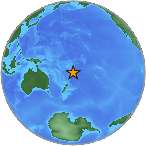
| Description |
English: w:2009 Tonga earthquake |
| Date | March 19 18:17:40 UTC |
| Source |
https://earthquake.usgs.gov/eqcenter/recenteqsww/Quakes/us2009ejbr.php#summary https://earthquake.usgs.gov/images/globes/-25_-175.jpg |
| Author | USGS |
Licensing
edit
This image is in the public domain in the United States because it only contains materials that originally came from the United States Geological Survey, an agency of the United States Department of the Interior. For more information, see the official USGS copyright policy.
|
File history
Click on a date/time to view the file as it appeared at that time.
| Date/Time | Thumbnail | Dimensions | User | Comment | |
|---|---|---|---|---|---|
| current | 17:25, 21 March 2009 | | 146 × 146 (4 KB) | Hgd0 (talk | contribs) | {{Information |Description={{en|1=w:2009 Tonga earthquake}} |Source=http://earthquake.usgs.gov/eqcenter/recenteqsww/Quakes/us2009ejbr.php#summary |Author=USGS |Date=2009 March 19 18:17:40 UTC |Permission= |other_versions= }} <!--{{ImageUpload|full}}- |
You cannot overwrite this file.
File usage on Commons
There are no pages that use this file.
File usage on other wikis
The following other wikis use this file:
- Usage on bg.wikipedia.org
- Usage on en.wikipedia.org
- Usage on es.wikipedia.org
- Usage on id.wikipedia.org
- Usage on ja.wikipedia.org