File:2010-09-02-Harpers-Ferry-From-Maryland-Heights-Panorama-Crop.jpg

Size of this preview: 800 × 357 pixels. Other resolutions: 320 × 143 pixels | 640 × 286 pixels | 1,024 × 457 pixels | 1,280 × 571 pixels | 2,560 × 1,143 pixels | 5,732 × 2,559 pixels.
Original file (5,732 × 2,559 pixels, file size: 8.36 MB, MIME type: image/jpeg)
Captions
Captions
Add a one-line explanation of what this file represents
Summary
edit
| Description |
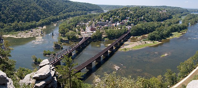
English: Panoramic view of Harpers Ferry from Maryland Heights, with the Shenandoah (left) and Potomac (right) rivers. (This is a cropped version, excluding the non-rectangular border which resulted from stitching.) |
| Date | |
| Source | Own work |
| Author | Mark Fickett |
| Other versions |
 |
| Camera location | | View this and other nearby images on: OpenStreetMap |
|---|
Licensing
edit
I, the copyright holder of this work, hereby publish it under the following license:
This file is licensed under the Creative Commons Attribution 3.0 Unported license.
- You are free:
- to share – to copy, distribute and transmit the work
- to remix – to adapt the work
- Under the following conditions:
- attribution – You must give appropriate credit, provide a link to the license, and indicate if changes were made. You may do so in any reasonable manner, but not in any way that suggests the licensor endorses you or your use.
File history
Click on a date/time to view the file as it appeared at that time.
| Date/Time | Thumbnail | Dimensions | User | Comment | |
|---|---|---|---|---|---|
| current | 16:10, 24 December 2010 | | 5,732 × 2,559 (8.36 MB) | Naib (talk | contribs) | {{Information |Description={{en|1=Panoramic view of Harpers Ferry from Maryland Heights, with the Shenandoah (left) and Potomac (right) rivers. (This is a cropped version, excluding the non-rectangular border which resulted from stitching.)}} |Source={{ow |
You cannot overwrite this file.
File usage on Commons
The following 7 pages use this file:
- User:Naib
- File:2010-09-02-Harpers-Ferry-From-Maryland-Heights-Panorama.jpg
- Category:Buildings in Harpers Ferry, West Virginia
- Category:Harpers Ferry, West Virginia
- Category:Harpers Ferry National Historical Park
- Category:Maps of Harpers Ferry National Historical Park
- Category:Museums in Harpers Ferry, West Virginia
File usage on other wikis
The following other wikis use this file:
- Usage on ar.wikipedia.org
- Usage on arz.wikipedia.org
- Usage on ca.wikipedia.org
- Usage on ceb.wikipedia.org
- Usage on ce.wikipedia.org
- Usage on dag.wikipedia.org
- Usage on da.wikipedia.org
- Usage on de.wikivoyage.org
- Usage on en.wikipedia.org
- Usage on en.wikivoyage.org
- Usage on es.wikipedia.org
- Usage on eu.wikipedia.org
- Usage on fa.wikipedia.org
- Usage on fr.wikipedia.org
- Usage on fr.wikivoyage.org
- Usage on he.wikipedia.org
- Usage on hu.wikipedia.org
- Usage on it.wikipedia.org
- Usage on lld.wikipedia.org
- Usage on lt.wikipedia.org
- Usage on mr.wikipedia.org
- Usage on no.wikipedia.org
- Usage on pl.wikipedia.org
- Usage on pt.wikipedia.org
- Usage on ru.wikipedia.org
- Usage on sh.wikipedia.org
- Usage on simple.wikipedia.org
- Usage on sr.wikipedia.org
- Usage on tt.wikipedia.org
- Usage on uk.wikipedia.org
- Usage on www.wikidata.org
- Usage on zh-min-nan.wikipedia.org