File:2010 Pakistan flood Khewali by Landsat-5 2010-08-12 small.jpg
2010_Pakistan_flood_Khewali_by_Landsat-5_2010-08-12_small.jpg (720 × 480 pixels, file size: 119 KB, MIME type: image/jpeg)
Captions
Captions
Summary edit
| Description2010 Pakistan flood Khewali by Landsat-5 2010-08-12 small.jpg |
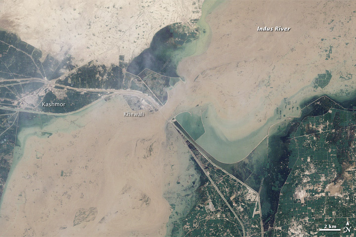
English: By mid-August, the extreme monsoon floods that had overwhelmed northwestern Pakistan had traveled downstream into southern Pakistan. The top image, acquired by the Landsat 5 satellite on August 12, 2010, shows flooding near Kashmor, Pakistan, just before the second wave of the flood hit. The lower image, provided for context, shows the region on August 9, 2009.
Even before the second wave reached this section of the Indus, floods covered much of the city of Khewali and the surrounding farmland. The flood-widened river is muddy and brown in the top image, and it impinges on the cement-gray town of Khewali. As if constrained by a belt, the river is cinched near Khewali. The constraint is the Guddu Barrage, a barrier designed to channel irrigation water to farmland in the northern Sindh district. The “C”-shaped barrier that controls the shape of the flood in the top image is itself visible in the lower image. Canals extend away from the barrage on both sides of the river. A road runs along the canal, and it too appears to be flooded. Stream gauges at the Guddu Barrage recorded extremely high levels of water (more than 910,000 cubic feet per second) flowing down the Indus on August 12. The flow rate increased on August 13 as the second wave of flooding reached the barrage. On August 18, the Pakistan government stated that 15.4 million people had been directly affected by the flood with nearly a million homes damaged or destroyed. The land along the Indus River is prime farmland, and nearly 80 percent of the flood victims are farmers who have lost crops, animals, and equipment. At least 3.2 million hectares of crops had been destroyed as of August 18, reported the United Nations Office for the Coordination of Humanitarian Affairs.Polski: Satelita Landsat 5 amerykańskiej agencji kosmicznej wykonał dramatyczne zdjęcia porównawcze obszarów Pakistanu dotkniętych sierpniową powodzią. Ukazują one okolice miasta Kaszmor, w prowincji Sindh, przed i po nadejściu drugiej fali powodziowej na Indusie. To najgorsza powódź w Pakistanie od 80 lat. Pochłonęła życie co najmniej 1600 osób.
W sierpniu północny-zachodni Pakistan został nawiedzony przez powódź związaną z monsunem. Satelita Landsat 5 uchwycił nadejście drugiej fali powodziowej 12 sierpnia nad miasto Khewali, koło Kaszmoru. Zdjęcie porównawcze wykonał ten sam satelita 9 sierpnia. Zamulone wody poszerzonego Indusu zalały większość Khewali. Wylew rzeki na pewne obszary częściowo powstrzymała Guddu Barrage, zapora kanału nawadniającego pola uprawne północnej części prowincji Sindh. Widoczna jest ona na zdjęciach jako łuk, w kształcie litery "C" bądź "L". Przepływ wody przez zaporę wynosił 12 sierpnia ponad 26000 m3/s, a dzień później uległ dalszemu zwiększeniu, z uwagi na falę powodziową. 18 sierpnia rząd Pakistanu ogłosił, że powódź dotknęła bezpośrednio 15,4 miliona mieszkańców kraju, niszcząc około miliona domostw. Brzegi Indusu to głównie pola uprawne - niemal 80% dotkniętych kataklizmem to rolnicy, którzy stracili plony, zwierzęta i maszyny. Według raportu Biura ONZ ds. Koordynacji Pomocy Humanitarnej zniszczeniu uległo 3,2 miliona hektarów pól uprawnych. Dystrykt Kaszmor prowincji Sindh jest jednym z liczniejszych w pogłowie bydła w Pakistanie i jednym z największych producentów ryżu w Azji. |
| Date | |
| Source | http://earthobservatory.nasa.gov/IOTD/view.php?id=45343 |
| Author | NASA |
| Other versions | 2010 Pakistan flood Khewali by Landsat-5 2010-08-12 big.jpg |
Licensing edit
| Public domainPublic domainfalsefalse |
| This file is in the public domain in the United States because it was solely created by NASA. NASA copyright policy states that "NASA material is not protected by copyright unless noted". (See Template:PD-USGov, NASA copyright policy page or JPL Image Use Policy.) |  | |
 |
Warnings:
|
File history
Click on a date/time to view the file as it appeared at that time.
| Date/Time | Thumbnail | Dimensions | User | Comment | |
|---|---|---|---|---|---|
| current | 09:53, 21 August 2010 |  | 720 × 480 (119 KB) | NH2501 (talk | contribs) | {{Information |Description={{en|1=By mid-August, the extreme monsoon floods that had overwhelmed northwestern Pakistan had traveled downstream into southern Pakistan. The top image, acquired by the Landsat 5 satellite on August 12, 2010, shows flooding ne |
You cannot overwrite this file.
File usage on Commons
There are no pages that use this file.
File usage on other wikis
The following other wikis use this file:
- Usage on en.wikipedia.org
- Usage on fa.wikipedia.org
- Usage on fr.wikipedia.org
- Usage on pl.wikinews.org
