File:2010 haiti shake map.jpg
Size of this preview: 464 × 599 pixels. Other resolutions: 186 × 240 pixels | 516 × 666 pixels.
Original file (516 × 666 pixels, file size: 178 KB, MIME type: image/jpeg)
Captions
Captions
Add a one-line explanation of what this file represents
Summary
edit
| Description |
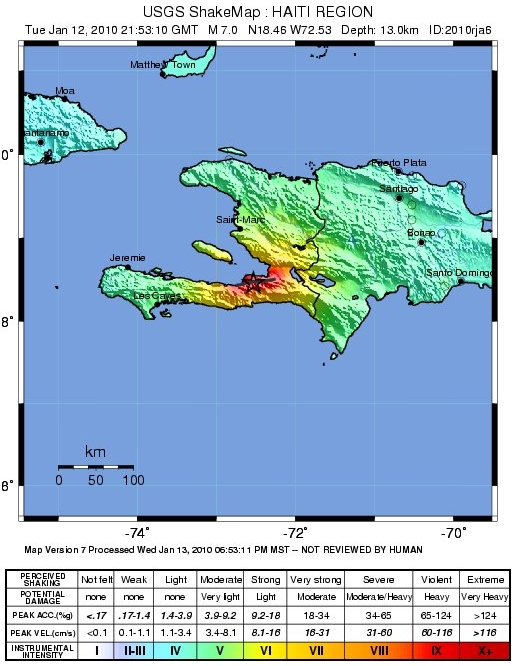
English: Shake map of 2010 Haiti earthquake |
| Date | |
| Source | https://web.archive.org/web/20100115110631/https://earthquake.usgs.gov/earthquakes/shakemap/global/shake/2010rja6/ |
| Author | USGS |
| Other versions | gg |
Licensing
edit
This image is in the public domain in the United States because it only contains materials that originally came from the United States Geological Survey, an agency of the United States Department of the Interior. For more information, see the official USGS copyright policy.
|
File history
Click on a date/time to view the file as it appeared at that time.
| Date/Time | Thumbnail | Dimensions | User | Comment | |
|---|---|---|---|---|---|
| current | 19:16, 19 January 2010 | | 516 × 666 (178 KB) | Fujnky (talk | contribs) | update and better quality |
| 14:42, 15 January 2010 |  | 543 × 672 (69 KB) | Dumelow (talk | contribs) | crop some whitespace | |
| 01:13, 13 January 2010 |  | 612 × 722 (83 KB) | Dumelow (talk | contribs) | {{Information |Description={{en|1=Shake map of 2010 Haiti earthquake}} |Source=http://earthquake.usgs.gov/earthquakes/shakemap/global/shake/2010rja6/ |Author=USGS |Date=12 jan 2010 |Permission= |other_versions= }} |
You cannot overwrite this file.
File usage on Commons
The following page uses this file:
File usage on other wikis
The following other wikis use this file:
- Usage on bg.wikinews.org
- Usage on da.wikipedia.org
- Usage on de.wikipedia.org
- Usage on en.wikipedia.org
- Usage on en.wikinews.org
- Usage on fi.wikipedia.org
- Usage on fr.wikipedia.org
- Usage on fr.wikinews.org
- Usage on hi.wikipedia.org
- Usage on hu.wikipedia.org
- Usage on id.wikipedia.org
- Usage on it.wikinews.org
- Usage on ja.wikipedia.org
- Usage on ki.wikipedia.org
- Usage on lt.wikipedia.org
- Usage on mk.wikipedia.org
- Usage on ms.wikipedia.org
- Usage on nds-nl.wikipedia.org
- Usage on nl.wikipedia.org
- Usage on pl.wikipedia.org
- Usage on pl.wikinews.org
- Usage on pt.wikipedia.org
- Usage on pt.wikinews.org
- Usage on sv.wikipedia.org
- Usage on ta.wikipedia.org
- Usage on tl.wikipedia.org
- Usage on tr.wikipedia.org
- Usage on uk.wikipedia.org
- Usage on vi.wikipedia.org