File:20130930 Kasteel Rechteren3a.jpg
Original file (1,538 × 2,144 pixels, file size: 2.9 MB, MIME type: image/jpeg)
Captions
Summary
edit
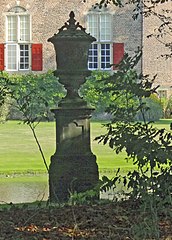
This is an image of rijksmonument number 510187 Information from structured data: |
Description20130930 Kasteel Rechteren3a.jpg |
Nederlands: Tuinvaas bij kasteel Rechteren nabij Dalfsen, detail van File:20130930 Kasteel Rechteren3.jpg |
Date | |
Source | Own work |
Author | Gouwenaar |
Other versions |
Camera location | 52° 29′ 48.16″ N, 6° 17′ 14.84″ E | View this and other nearby images on: OpenStreetMap | 52.496711; 6.287456 |
---|
Licensing
editThis file is made available under the Creative Commons CC0 1.0 Universal Public Domain Dedication. | |
The person who associated a work with this deed has dedicated the work to the public domain by waiving all of their rights to the work worldwide under copyright law, including all related and neighboring rights, to the extent allowed by law. You can copy, modify, distribute and perform the work, even for commercial purposes, all without asking permission.
http://creativecommons.org/publicdomain/zero/1.0/deed.enCC0Creative Commons Zero, Public Domain Dedicationfalsefalse |
File history
Click on a date/time to view the file as it appeared at that time.
Date/Time | Thumbnail | Dimensions | User | Comment | |
---|---|---|---|---|---|
current | 19:43, 1 October 2013 | 1,538 × 2,144 (2.9 MB) | Gouwenaar (talk | contribs) | {{Rijksmonument|510171}} {{Information |Description={{nl|Tuinvaas bij kasteel Rechteren nabij Dalfsen, detail van File:20130930 Kasteel Rechteren3.jpg }} |Source={{own}} |Date=2013-09-30 |Author= Gouwenaar |Permission= |other_ve... |
You cannot overwrite this file.
File usage on Commons
The following page uses this file:
File usage on other wikis
The following other wikis use this file:
- Usage on nl.wikipedia.org
Metadata
This file contains additional information such as Exif metadata which may have been added by the digital camera, scanner, or software program used to create or digitize it. If the file has been modified from its original state, some details such as the timestamp may not fully reflect those of the original file. The timestamp is only as accurate as the clock in the camera, and it may be completely wrong.
Image title |
|
---|---|
Camera manufacturer | SONY |
Camera model | DSC-HX20V |
Exposure time | 1/320 sec (0.003125) |
F-number | f/5 |
ISO speed rating | 100 |
Date and time of data generation | 12:22, 30 September 2013 |
Lens focal length | 26.22 mm |
Latitude | 52° 29′ 48.16″ N |
Longitude | 6° 17′ 14.84″ E |
Altitude | 15.4 meters below sea level |
Width | 3,672 px |
Height | 4,896 px |
Bits per component |
|
Pixel composition | RGB |
Orientation | Normal |
Number of components | 3 |
Horizontal resolution | 72 dpi |
Vertical resolution | 72 dpi |
Software used | Adobe Photoshop Elements 11.0 Macintosh |
File change date and time | 21:37, 1 October 2013 |
Exposure Program | Normal program |
Exif version | 2.3 |
Date and time of digitizing | 12:22, 30 September 2013 |
Meaning of each component |
|
Image compression mode | 3 |
APEX shutter speed | 8.321928 |
APEX aperture | 4.643856 |
APEX brightness | 8.2125 |
APEX exposure bias | 0 |
Maximum land aperture | 4.640625 APEX (f/4.99) |
Metering mode | Pattern |
Light source | Unknown |
Flash | Flash did not fire, compulsory flash suppression |
Supported Flashpix version | 1 |
Color space | Uncalibrated |
File source | Digital still camera |
Custom image processing | Normal process |
Exposure mode | Auto exposure |
White balance | Auto white balance |
Digital zoom ratio | 1 |
Scene capture type | Standard |
Contrast | Normal |
Saturation | Normal |
Sharpness | Normal |
GPS time (atomic clock) | 10:22 |
Receiver status | Measurement in progress |
Measurement mode | 3-dimensional measurement |
Measurement precision | Poor (1.22) |
Speed unit | Kilometers per hour |
Speed of GPS receiver | 0.936 |
Reference for direction of movement | True direction |
Direction of movement | 37.99 |
Reference for direction of image | Magnetic direction |
Direction of image | 56.25 |
Geodetic survey data used | WGS-84 |
GPS date | 30 September 2013 |
GPS differential correction | 0 |
GPS tag version | 2.3.0.0 |
Lens used | 4.5-89.0 mm f/3.2-5.8 |
Date metadata was last modified | 23:37, 1 October 2013 |
Unique ID of original document | D9D10CF0D7B8BADFDA4D94B09306891B |
IIM version | 2 |