File:20151117 Morocco 2419 Meknes sRGB.jpg

Original file (3,648 × 2,736 pixels, file size: 1.5 MB, MIME type: image/jpeg)
Captions
Captions
Summary
edit
| Description |
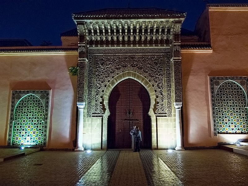
English: We arrive at the Moulay Ismail Mausoleum just at closing time but are allowed inside for a last-minute visit. It is one of only four sacred sites in Morocco open to non-Muslims. The mausoleum was built in 1703, twenty-four years before Moulay Ismail died.
Moulay Ismail ibn Sharif, the ‘Warrior King,’ reigned over Morocco from 1672 until his death in 1727, succeeding his half-brother as the second ruler of the Moroccan Alaouite dynasty which continues with the current Moroccan royal family [distinct from the Shia Alawites ruling Syria]. His cruelty is legendary, having killed an estimated 30,000 people during his rule. He is also alleged to have fathered a total of 867 children (525 sons and 342 daughters)! Moulay Ismail is considered one of the greatest figures in Moroccan history for achieving independence from the Ottoman Turks and expelling the English and the Spanish. He had excellent relations, however, with Louis XIV of France, the enemy of Spain. Moulay Ismail moved the Moroccan capital from Fez to Meknès. His building program here relied on slaves, many of whom were Christians obtained from raids on Western Europe by Barbary pirates, and used recycled stones plundered from the Roman ruins at Volubilis. The Moulay Ismail Mausoleum is open to non-Muslims in honor of his ecumenical instincts evidenced by commercial treaties with Europe. The Historic City of Meknes became a UNESCO World Heritage Site in 1996. On Google Earth: Moulay Ismail Mausoleum 33°53'26.93"N, 5°33'48.17"W |
| Date | |
| Source | https://www.flickr.com/photos/9508280@N07/24401380051/ |
| Author | Dan Lundberg |
| Camera location | | View this and other nearby images on: OpenStreetMap |
|---|
Licensing
edit
- You are free:
- to share – to copy, distribute and transmit the work
- to remix – to adapt the work
- Under the following conditions:
- attribution – You must give appropriate credit, provide a link to the license, and indicate if changes were made. You may do so in any reasonable manner, but not in any way that suggests the licensor endorses you or your use.
- share alike – If you remix, transform, or build upon the material, you must distribute your contributions under the same or compatible license as the original.
| This image was originally posted to Flickr by Dan Lundberg at https://flickr.com/photos/9508280@N07/24401380051. It was reviewed on 15 November 2022 by FlickreviewR 2 and was confirmed to be licensed under the terms of the cc-by-sa-2.0. |
File history
Click on a date/time to view the file as it appeared at that time.
| Date/Time | Thumbnail | Dimensions | User | Comment | |
|---|---|---|---|---|---|
| current | 16:17, 15 November 2022 | | 3,648 × 2,736 (1.5 MB) | أيوب (talk | contribs) | Uploaded a work by Dan Lundberg from https://www.flickr.com/photos/9508280@N07/24401380051/ with UploadWizard |
You cannot overwrite this file.
File usage on Commons
There are no pages that use this file.