File:2015 Rough Fire map 1.png

Size of this preview: 800 × 578 pixels. Other resolutions: 320 × 231 pixels | 640 × 462 pixels | 1,024 × 740 pixels | 1,280 × 924 pixels | 1,800 × 1,300 pixels.
Original file (1,800 × 1,300 pixels, file size: 4.41 MB, MIME type: image/png)
Captions
Captions
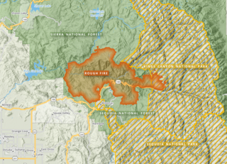
This map shows the footprint of the 2015 Rough Fire in the Sierra and Sequoia National Forests and Kings Canyon National Park
Summary edit
| Description |
English: The Rough Fire burned more than 150,000 acres in Fresno County, California, in 2015. It was, at the time, the 13th largest wildfire in recorded Californian history. This map was made in QGIS using data from the California Department of Forestry and Fire Protection (Cal Fire), the National Hydrography Dataset (NHD), OpenStreetMap, and others. |
| Date | |
| Source | Own work |
| Author | Penitentes |
Licensing edit
I, the copyright holder of this work, hereby publish it under the following license:
This file is licensed under the Creative Commons Attribution-Share Alike 4.0 International license.
- You are free:
- to share – to copy, distribute and transmit the work
- to remix – to adapt the work
- Under the following conditions:
- attribution – You must give appropriate credit, provide a link to the license, and indicate if changes were made. You may do so in any reasonable manner, but not in any way that suggests the licensor endorses you or your use.
- share alike – If you remix, transform, or build upon the material, you must distribute your contributions under the same or compatible license as the original.
File history
Click on a date/time to view the file as it appeared at that time.
| Date/Time | Thumbnail | Dimensions | User | Comment | |
|---|---|---|---|---|---|
| current | 04:11, 10 February 2024 | | 1,800 × 1,300 (4.41 MB) | Penitentes (talk | contribs) | Fixed labels, slightly diff crop |
| 02:49, 10 February 2024 |  | 1,800 × 1,302 (4.42 MB) | Penitentes (talk | contribs) | Uploaded own work with UploadWizard |
You cannot overwrite this file.
File usage on Commons
There are no pages that use this file.
File usage on other wikis
The following other wikis use this file:
- Usage on en.wikipedia.org