File:20161001 East Bay, Nova Scotia 4.jpg

Size of this preview: 800 × 533 pixels. Other resolutions: 320 × 213 pixels | 640 × 427 pixels | 1,024 × 683 pixels | 1,280 × 853 pixels | 2,560 × 1,707 pixels | 3,888 × 2,592 pixels.
Original file (3,888 × 2,592 pixels, file size: 4.93 MB, MIME type: image/jpeg)
Captions
Captions
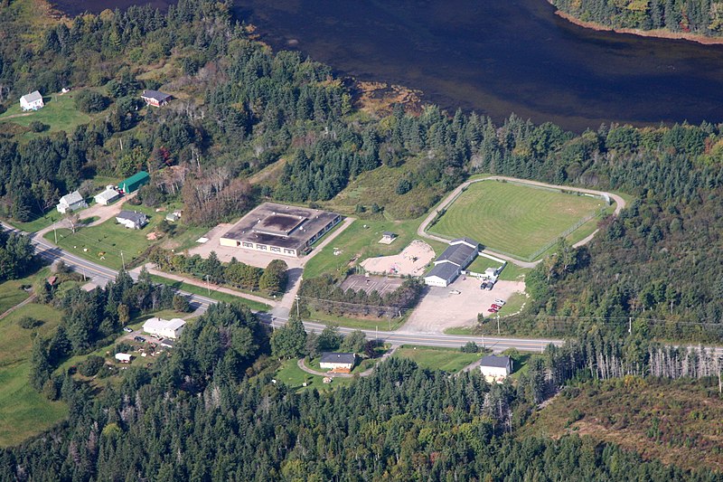
An aerial view of the Volunteer Fire Department, Ball field, and former Elementary School in the community of East Bay, Nova Scotia.
Summary
edit
| Description |
English: East Bay is a community in the Canadian province of Nova Scotia, located in the Cape Breton Regional Municipality on Cape Breton Island. It is situated on the south side of the East Bay of the Bras d'Or Lake, from which it gets its name. East Bay has one public beach (East Bay Sandbar) and a large number of summer cottages with beach front property.
East Bay has a Volunteer Fire Department, a Playground, and a Ball field, all visible in the photo. The former Elementary School can also be seen. The community was the site of the College of East Bay (1824-1829) which was moved to Arichat and later Antigonish where it became St. Francis Xavier University. |
| Date | |
| Source | Own work |
| Author | Ken Heaton |
| Camera location | | View this and other nearby images on: OpenStreetMap |
|---|
Licensing
edit
I, the copyright holder of this work, hereby publish it under the following license:
This file is licensed under the Creative Commons Attribution-Share Alike 4.0 International license.
- You are free:
- to share – to copy, distribute and transmit the work
- to remix – to adapt the work
- Under the following conditions:
- attribution – You must give appropriate credit, provide a link to the license, and indicate if changes were made. You may do so in any reasonable manner, but not in any way that suggests the licensor endorses you or your use.
- share alike – If you remix, transform, or build upon the material, you must distribute your contributions under the same or compatible license as the original.
File history
Click on a date/time to view the file as it appeared at that time.
| Date/Time | Thumbnail | Dimensions | User | Comment | |
|---|---|---|---|---|---|
| current | 15:02, 10 April 2020 | | 3,888 × 2,592 (4.93 MB) | Ken Heaton (talk | contribs) | Uploaded own work with UploadWizard |
You cannot overwrite this file.
File usage on Commons
The following 3 pages use this file:
File usage on other wikis
The following other wikis use this file:
- Usage on en.wikipedia.org