File:2017 Avian Influenza Outbreak controlled radius map in Pampanga, Philippines.jpg
Size of this preview: 800 × 555 pixels. Other resolutions: 320 × 222 pixels | 640 × 444 pixels | 1,024 × 710 pixels | 1,280 × 888 pixels | 2,560 × 1,776 pixels | 3,083 × 2,139 pixels.
Original file (3,083 × 2,139 pixels, file size: 3.2 MB, MIME type: image/jpeg)
Captions
Captions
Add a one-line explanation of what this file represents
Summary edit
| Description |
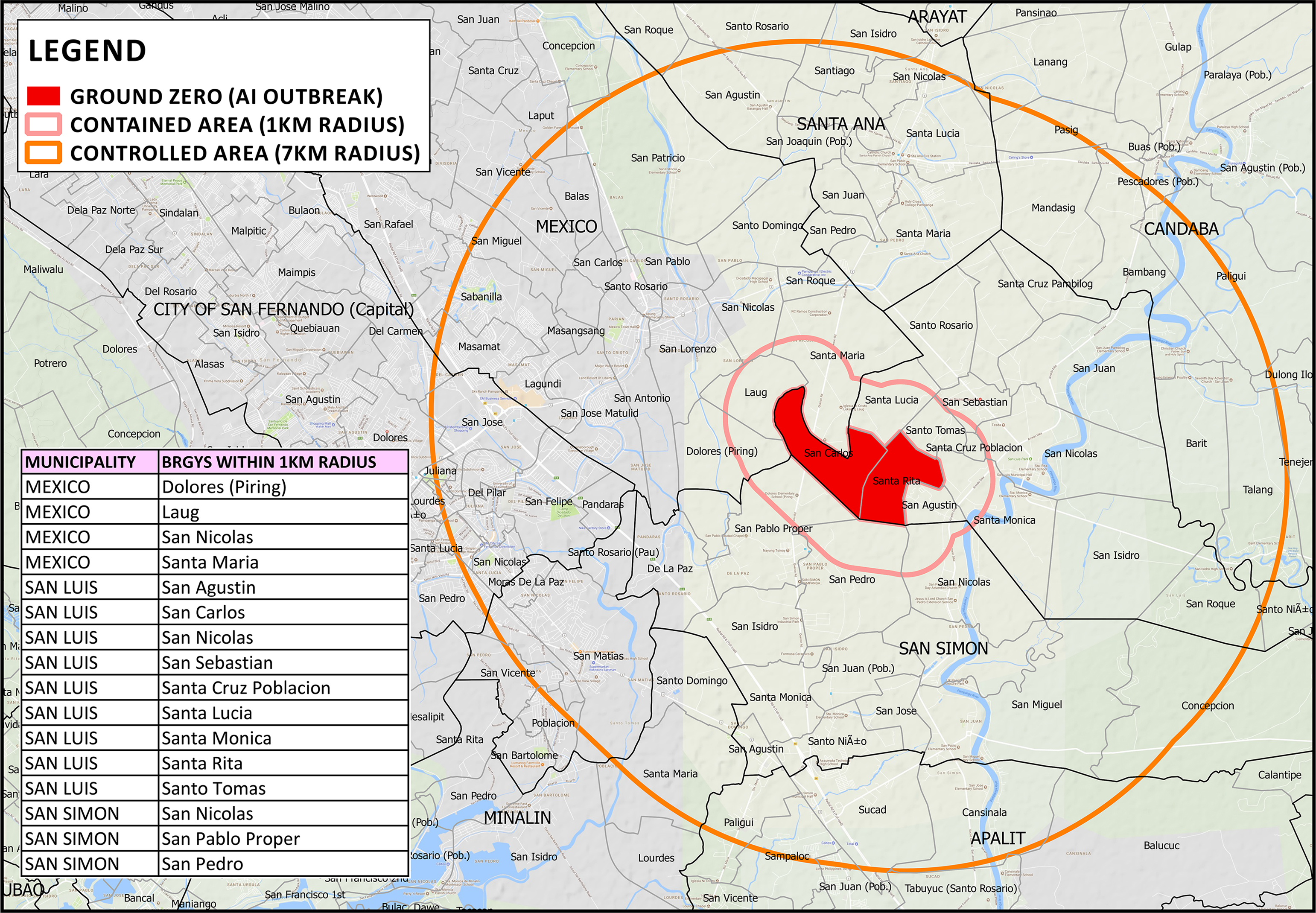
English: Map of depicting 7-km radius "Controlled Area" and 1-km "Contained Area" from the ground zero of the avian influenza outbreak affecting the barangays of San Carlos and Santa Rita in San Luis, Pampanga. |
| Date | |
| Source | Department of Agriculture - Avian Influenza Outbreak |
| Author | Department of Agriculture (Philippines) |
Licensing edit
| This work is in the public domain in the Philippines and possibly other jurisdictions because it is a work created by an officer or employee of the Government of the Philippines or any of its subdivisions and instrumentalities, including government-owned and/or controlled corporations, as part of their regularly prescribed official duties; consequently, any work is ineligible for copyright under the terms of Part IV, Chapter I, Section 171.11 and Part IV, Chapter IV, Section 176 of Republic Act No. 8293 and Republic Act No. 10372, as amended, unless otherwise noted. However, in some instances, the use of this work in the Philippines or elsewhere may be regulated by this law or other laws.
|

|
File history
Click on a date/time to view the file as it appeared at that time.
| Date/Time | Thumbnail | Dimensions | User | Comment | |
|---|---|---|---|---|---|
| current | 03:08, 9 September 2019 | | 3,083 × 2,139 (3.2 MB) | Hariboneagle927 (talk | contribs) | User created page with UploadWizard |
You cannot overwrite this file.
File usage on Commons
There are no pages that use this file.
File usage on other wikis
The following other wikis use this file:
- Usage on en.wikipedia.org
- Usage on tl.wikipedia.org