File:2017 United States Senate special election in Alabama results map by county.svg

Size of this PNG preview of this SVG file: 600 × 600 pixels. Other resolutions: 240 × 240 pixels | 480 × 480 pixels | 768 × 768 pixels | 1,024 × 1,024 pixels | 2,048 × 2,048 pixels | 810 × 810 pixels.
Original file (SVG file, nominally 810 × 810 pixels, file size: 43 KB)
Captions
Captions
Add a one-line explanation of what this file represents
Summary
edit
| Description |
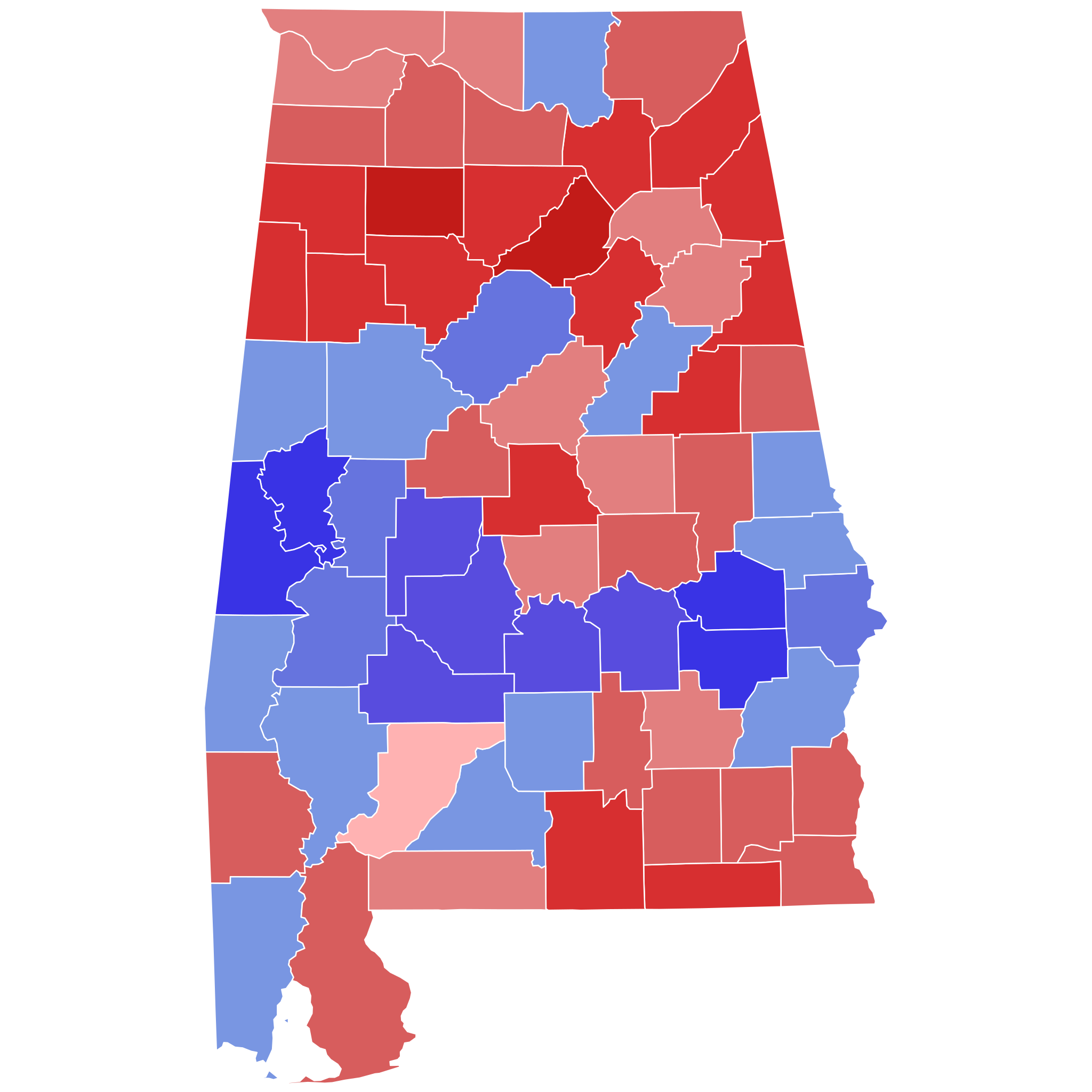
Percentage of the vote each candidate took in the 2017 U.S. Senate special election in Alabama by county. Data used to create map is from Politico.
Moore 40% 50% 60% 70% 80% Jones 40% 50% 60% 70% 80%
|
|
| Date | ||
| Source | Own work | |
| Author | WClarke |
Licensing
edit
I, the copyright holder of this work, hereby publish it under the following license:
This file is licensed under the Creative Commons Attribution-Share Alike 4.0 International license.
- You are free:
- to share – to copy, distribute and transmit the work
- to remix – to adapt the work
- Under the following conditions:
- attribution – You must give appropriate credit, provide a link to the license, and indicate if changes were made. You may do so in any reasonable manner, but not in any way that suggests the licensor endorses you or your use.
- share alike – If you remix, transform, or build upon the material, you must distribute your contributions under the same or compatible license as the original.
File history
Click on a date/time to view the file as it appeared at that time.
| Date/Time | Thumbnail | Dimensions | User | Comment | |
|---|---|---|---|---|---|
| current | 16:08, 21 June 2023 | | 810 × 810 (43 KB) | Putitonamap98 (talk | contribs) | shapes |
| 10:55, 30 December 2022 |  | 744 × 744 (329 KB) | Putitonamap98 (talk | contribs) | Reverted to version as of 10:55, 30 December 2022 (UTC) | |
| 10:55, 30 December 2022 |  | 744 × 744 (329 KB) | Putitonamap98 (talk | contribs) | Reverted to version as of 10:38, 30 December 2022 (UTC) | |
| 10:55, 30 December 2022 |  | 744 × 744 (329 KB) | Putitonamap98 (talk | contribs) | shapes | |
| 10:38, 30 December 2022 |  | 744 × 744 (329 KB) | Putitonamap98 (talk | contribs) | Reverted to version as of 11:40, 25 December 2022 (UTC) | |
| 00:59, 30 December 2022 |  | 139 × 223 (43 KB) | HoustonFootball (talk | contribs) | Reverted to version as of 19:05, 29 July 2018 (UTC) | |
| 11:40, 25 December 2022 |  | 744 × 744 (329 KB) | Putitonamap98 (talk | contribs) | shapes | |
| 19:05, 29 July 2018 |  | 139 × 223 (43 KB) | Count Awesome (talk | contribs) | Standardized format for Alabama Senate map would be thicker lines serving as boundaries between counties | |
| 16:15, 7 April 2018 |  | 139 × 223 (40 KB) | Kingofthedead (talk | contribs) | Reverted to version as of 04:19, 27 January 2018 (UTC) | |
| 22:35, 6 April 2018 |  | 139 × 223 (43 KB) | Count Awesome (talk | contribs) | Reverted to version as of 04:32, 23 January 2018 (UTC) |
You cannot overwrite this file.
File usage on Commons
The following 8 pages use this file:
- User:Magog the Ogre/Political maps/2017 December 11-20
- User:Magog the Ogre/Political maps/2018 April 1-10
- User:Magog the Ogre/Political maps/2018 January 1-10
- User:Magog the Ogre/Political maps/2018 January 21-31
- User:Magog the Ogre/Political maps/2018 July 21-31
- User:Magog the Ogre/Political maps/2022 December 21-31
- User:Magog the Ogre/Political maps/2023 June 21-30
- User talk:Magog the Ogre/Archive 24
File usage on other wikis
The following other wikis use this file:
- Usage on de.wikipedia.org
- Usage on eml.wikipedia.org
- Usage on en.wikipedia.org
- Usage on es.wikipedia.org
- Usage on fr.wikipedia.org
- Usage on id.wikipedia.org
- Usage on ru.wikipedia.org