File:201803-Groesbeek-3D.jpg

Size of this preview: 800 × 468 pixels. Other resolutions: 320 × 187 pixels | 640 × 374 pixels | 1,024 × 599 pixels | 1,517 × 887 pixels.
Original file (1,517 × 887 pixels, file size: 403 KB, MIME type: image/jpeg)
Captions
Captions
Add a one-line explanation of what this file represents
Summary
edit
| Description |
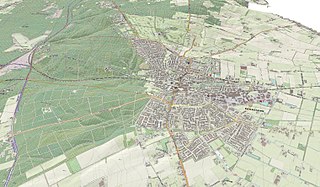
English: Topographic 3-D map of the Dutch town of Groesbeek, made using Dutch AHN2 elevation dataset (CC-BY Kadaster) and OpenTopo reference map (CC-BY Jan-Willem van Aalst), in QGIS 3.0. Topographic data: Nov. 2017
Nederlands: Topografische 3-D kaart van Groesbeek, gemaakt met het AHN2 hoogtebestand (CC-BY Kadaster) en de OpenTopo referentiekaart (CC-BY Jan-Willem van Aalst), met QGIS 3.0. Topografische data van nov. 2017. |
| Date | |
| Source | Own work |
| Author | Janwillemvanaalst |
Licensing
edit
I, the copyright holder of this work, hereby publish it under the following license:
This file is licensed under the Creative Commons Attribution-Share Alike 4.0 International license.
- You are free:
- to share – to copy, distribute and transmit the work
- to remix – to adapt the work
- Under the following conditions:
- attribution – You must give appropriate credit, provide a link to the license, and indicate if changes were made. You may do so in any reasonable manner, but not in any way that suggests the licensor endorses you or your use.
- share alike – If you remix, transform, or build upon the material, you must distribute your contributions under the same or compatible license as the original.
File history
Click on a date/time to view the file as it appeared at that time.
| Date/Time | Thumbnail | Dimensions | User | Comment | |
|---|---|---|---|---|---|
| current | 19:57, 23 March 2018 | | 1,517 × 887 (403 KB) | Janwillemvanaalst (talk | contribs) | User created page with UploadWizard |
You cannot overwrite this file.
File usage on Commons
There are no pages that use this file.
File usage on other wikis
The following other wikis use this file:
- Usage on nl.wikipedia.org