File:2019 Northwestern Syria Offensive.svg

Size of this PNG preview of this SVG file: 360 × 599 pixels. Other resolutions: 144 × 240 pixels | 288 × 480 pixels | 461 × 768 pixels | 615 × 1,024 pixels | 1,231 × 2,048 pixels | 1,647 × 2,740 pixels.
Original file (SVG file, nominally 1,647 × 2,740 pixels, file size: 9.35 MB)
Captions
Captions
Add a one-line explanation of what this file represents
Summary edit
| Description |
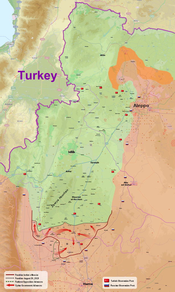
English: Map of the 2019 Northwestern Syria Offensive launched by pro-regime forces.
Controlled by the Syrian Arab Republic
Controlled by the Syrian opposition
Controlled by both Syrian Arab Republic and Syrian Democratic Forces |
| Date | |
| Source | Based on https://en.wikipedia.org/wiki/File:Northwestern_Syria_%26_Aleppo_offensives_2015.svg |
| Author | Derived from work by MrPenguin20 |
Licensing edit
This file is licensed under the Creative Commons Attribution-Share Alike 4.0 International license.
- You are free:
- to share – to copy, distribute and transmit the work
- to remix – to adapt the work
- Under the following conditions:
- attribution – You must give appropriate credit, provide a link to the license, and indicate if changes were made. You may do so in any reasonable manner, but not in any way that suggests the licensor endorses you or your use.
- share alike – If you remix, transform, or build upon the material, you must distribute your contributions under the same or compatible license as the original.
File history
Click on a date/time to view the file as it appeared at that time.
| Date/Time | Thumbnail | Dimensions | User | Comment | |
|---|---|---|---|---|---|
| current | 15:06, 30 August 2019 | | 1,647 × 2,740 (9.35 MB) | Rr016 (talk | contribs) | Update: with Khan Shaykhun outskirts secured and Tamanah taken, pro-government forces have completed their first stage of the Idlib operation - pushing opposition out of northern Hama. |
| 16:07, 23 August 2019 |  | 1,647 × 2,740 (9.34 MB) | Rr016 (talk | contribs) | Update: government forces take full control of northern Hama area, not sure what will happen to Turkish OP | |
| 19:37, 21 August 2019 |  | 1,647 × 2,740 (9.34 MB) | Rr016 (talk | contribs) | Big update: Khan Shaykhun taken by government forces, encircling northern Hama territory | |
| 15:54, 14 August 2019 |  | 1,647 × 2,740 (9.34 MB) | Rr016 (talk | contribs) | Update: government forces are advancing upon Khan Shikhoun from the west and east directions, encirclement of northern Hama territory likely | |
| 18:37, 29 July 2019 |  | 1,647 × 2,740 (9.33 MB) | Rr016 (talk | contribs) | Update: all rebel gains have been reversed | |
| 00:07, 7 June 2019 |  | 1,647 × 2,740 (9.33 MB) | Rr016 (talk | contribs) | Government advances north of Kafr Nabudah, opposition advances to the south | |
| 20:31, 22 May 2019 |  | 1,647 × 2,740 (9.31 MB) | Rr016 (talk | contribs) | After a brief few days of quiet, things are starting to escalate; Kafr Nabudah is having fierce clashes, added Turkish OP to the map, corrections to frontlines... | |
| 21:19, 12 May 2019 |  | 1,647 × 2,740 (13.02 MB) | Rr016 (talk | contribs) | Test to see if I can upload an SVG file with more than 10MB | |
| 22:21, 9 May 2019 |  | 1,647 × 2,740 (9.29 MB) | Rr016 (talk | contribs) | User created page with UploadWizard |
You cannot overwrite this file.
File usage on Commons
The following 5 pages use this file:
File usage on other wikis
The following other wikis use this file:
- Usage on ar.wikipedia.org
- Usage on de.wikipedia.org
- Usage on en.wikipedia.org
- Usage on fa.wikipedia.org
- Usage on fr.wikipedia.org
- Usage on ko.wikipedia.org
- Usage on www.wikidata.org