File:2020-12-29 Petrinja, Croatia M6.4 earthquake shakemap (USGS).jpg
Size of this preview: 472 × 599 pixels. Other resolutions: 189 × 240 pixels | 378 × 480 pixels | 787 × 999 pixels.
Original file (787 × 999 pixels, file size: 462 KB, MIME type: image/jpeg)
Captions
Captions
petrinja ,earthquake
Summary edit
.jpg&action=edit§ion=1)
| Description |
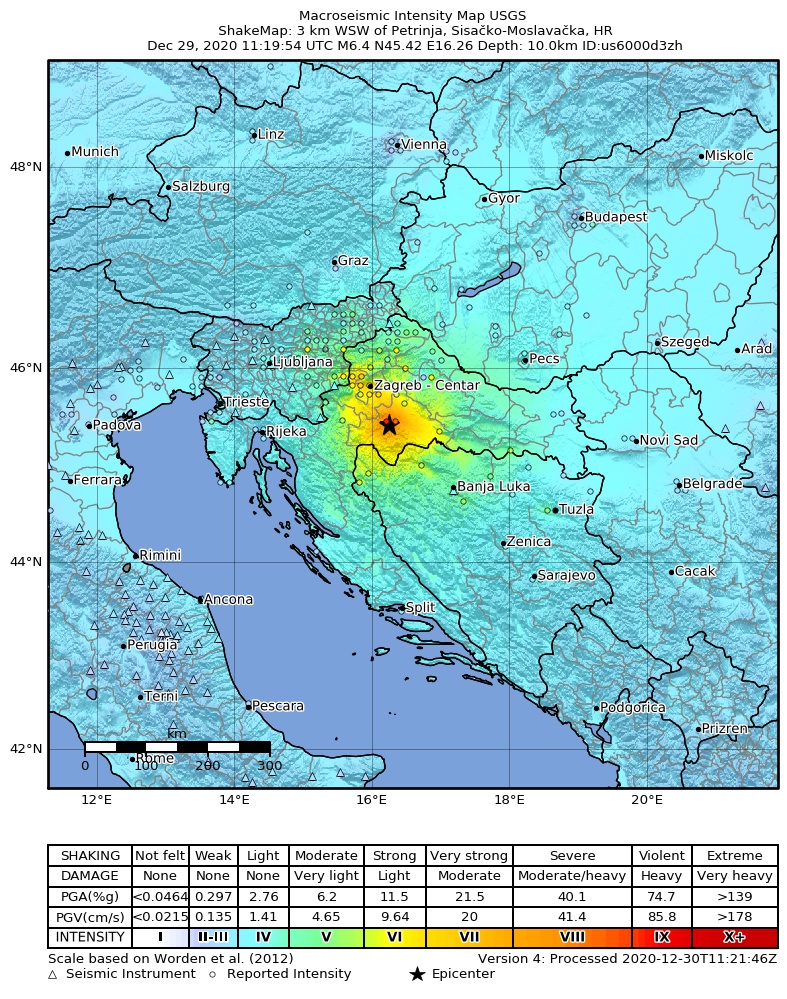
English: Shakemap from USGS for the magnitude 6.4, maximum intensity 6.826 earthquake near en:Usgs Neic Shakemap (2 km SSE of en:Petrinja, Croatia), 10.0 km depth. |
| Date | |
| Source | https://earthquake.usgs.gov/earthquakes/eventpage/us6000d3zh |
| Author | United States Geological Survey |
Licensing edit
.jpg&action=edit§ion=2)
This image is in the public domain in the United States because it only contains materials that originally came from the United States Geological Survey, an agency of the United States Department of the Interior. For more information, see the official USGS copyright policy.
|
File history
Click on a date/time to view the file as it appeared at that time.
| Date/Time | Thumbnail | Dimensions | User | Comment | |
|---|---|---|---|---|---|
| current | 12:30, 31 December 2020 | | 787 × 999 (462 KB) | IllCom (talk | contribs) | new version by USGS |
| 22:10, 29 December 2020 |  | 787 × 999 (460 KB) | IllCom (talk | contribs) | new version by USGS | |
| 13:10, 29 December 2020 |  | 787 × 999 (460 KB) | IllCom (talk | contribs) | new version by USGS | |
| 12:03, 29 December 2020 |  | 787 × 999 (454 KB) | Cewbot (talk | contribs) | Import USGS earthquake map, shakemap id: urn:usgs-product:us:shakemap:us6000d3zh:1609242281073 (2020-12-29T11:44:41.073Z) |
You cannot overwrite this file.
File usage on Commons
There are no pages that use this file.
File usage on other wikis
The following other wikis use this file:
- Usage on bs.wikipedia.org
- Usage on cs.wikipedia.org
- Usage on de.wikipedia.org
- Usage on el.wikipedia.org
- Usage on en.wikipedia.org
- Usage on es.wikipedia.org
- Usage on fa.wikipedia.org
- Usage on fi.wikipedia.org
- Usage on hr.wikipedia.org
- Usage on hu.wikipedia.org
- Usage on id.wikipedia.org
- Usage on it.wikipedia.org
- Usage on pl.wikipedia.org
- Usage on ru.wikipedia.org
- Usage on sh.wikipedia.org
- Usage on sl.wikipedia.org
- Usage on sv.wikipedia.org
- Usage on ta.wikipedia.org
- Usage on th.wikipedia.org
- Usage on tr.wikipedia.org
- Usage on www.wikidata.org
- Usage on zh.wikipedia.org
.jpg&oldid=860437870)