File:2020 Senate election map.png

Size of this preview: 800 × 520 pixels. Other resolutions: 320 × 208 pixels | 640 × 416 pixels | 1,024 × 665 pixels | 1,513 × 983 pixels.
Original file (1,513 × 983 pixels, file size: 45 KB, MIME type: image/png)
Captions
Captions
Add a one-line explanation of what this file represents
Summary
edit
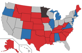
| Description |
English: Democratic incumbent
Retiring Democrat
Republican incumbent
Retiring Republican
Undetermined incumbent
No election |
| Date | 25 November 2014 (original upload date) |
| Source | Transferred from en.wikipedia to Commons. |
| Author | Orser67 at English Wikipedia |
Licensing
edit
Orser67 at English Wikipedia, the copyright holder of this work, hereby publishes it under the following licenses:
This file is licensed under the Creative Commons Attribution-Share Alike 3.0 Unported license.
Attribution: Orser67 at English Wikipedia
- You are free:
- to share – to copy, distribute and transmit the work
- to remix – to adapt the work
- Under the following conditions:
- attribution – You must give appropriate credit, provide a link to the license, and indicate if changes were made. You may do so in any reasonable manner, but not in any way that suggests the licensor endorses you or your use.
- share alike – If you remix, transform, or build upon the material, you must distribute your contributions under the same or compatible license as the original.

|
Permission is granted to copy, distribute and/or modify this document under the terms of the GNU Free Documentation License, Version 1.2 or any later version published by the Free Software Foundation; with no Invariant Sections, no Front-Cover Texts, and no Back-Cover Texts. A copy of the license is included in the section entitled GNU Free Documentation License. |
You may select the license of your choice.
Original upload log
edit
The original description page was here. All following user names refer to en.wikipedia.
| Date/Time | Dimensions | User | Comment |
|---|---|---|---|
| 2015-01-08 12:49 | 1513×983× (40200 bytes) | Orser67 | Fixed Hawaii |
| 2014-12-09 08:18 | 1513×983× (40355 bytes) | Orser67 | |
| 2014-12-09 08:15 | 1513×983× (40291 bytes) | Orser67 | |
| 2014-12-09 08:14 | 1513×983× (40331 bytes) | Orser67 | Post LA runoff |
| 2014-11-25 18:40 | 1513×983× (40095 bytes) | Orser67 | Own work |
File history
Click on a date/time to view the file as it appeared at that time.
| Date/Time | Thumbnail | Dimensions | User | Comment | |
|---|---|---|---|---|---|
| current | 13:47, 12 February 2018 | | 1,513 × 983 (45 KB) | Foghe (talk | contribs) | Transparent background. |
| 05:55, 5 January 2018 |  | 1,513 × 983 (49 KB) | Prcc27 (talk | contribs) | MN Franken resigned. | |
| 19:10, 13 December 2017 |  | 1,513 × 983 (45 KB) | Foghe (talk | contribs) | Transparent background. | |
| 05:30, 13 December 2017 |  | 1,513 × 983 (36 KB) | Ridingincar (talk | contribs) | Set Alabama to Democratic incumbent in light of today's special election results. | |
| 19:48, 12 October 2017 |  | 1,513 × 983 (39 KB) | Orser67 (talk | contribs) | Set Alabama to unknown incumbent | |
| 00:06, 5 May 2015 |  | 1,513 × 983 (39 KB) | OgreBot (talk | contribs) | (BOT): Reverting to most recent version before archival | |
| 00:06, 5 May 2015 |  | 1,513 × 983 (39 KB) | OgreBot (talk | contribs) | (BOT): Uploading old version of file from en.wikipedia; originally uploaded on 2014-12-09 08:18:07 by Orser67 | |
| 00:06, 5 May 2015 |  | 1,513 × 983 (39 KB) | OgreBot (talk | contribs) | (BOT): Uploading old version of file from en.wikipedia; originally uploaded on 2014-12-09 08:15:52 by Orser67 | |
| 00:06, 5 May 2015 |  | 1,513 × 983 (39 KB) | OgreBot (talk | contribs) | (BOT): Uploading old version of file from en.wikipedia; originally uploaded on 2014-12-09 08:14:34 by Orser67 | |
| 00:06, 5 May 2015 |  | 1,513 × 983 (39 KB) | OgreBot (talk | contribs) | (BOT): Uploading old version of file from en.wikipedia; originally uploaded on 2014-11-25 18:40:11 by Orser67 |
You cannot overwrite this file.
File usage on Commons
The following 8 pages use this file:
- User:Magog the Ogre/Political maps/2015 April
- User:Magog the Ogre/Political maps/2015 May
- User:Magog the Ogre/Political maps/2017 December 11-20
- User:Magog the Ogre/Political maps/2017 October 11-20
- User:Magog the Ogre/Political maps/2018 February 10-18
- User:Magog the Ogre/Political maps/2018 January 1-10
- User:Magog the Ogre/election maps/2015 April
- User:Magog the Ogre/election maps/2015 May