File:2021 CIMSS 01W One visible infrared map.GIF
No higher resolution available.
2021_CIMSS_01W_One_visible_infrared_map.GIF (800 × 600 pixels, file size: 4.21 MB, MIME type: image/gif, looped, 12 frames, 2.7 s)
Captions
Captions
Add a one-line explanation of what this file represents
Summary edit
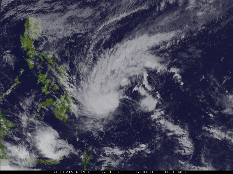
| Description |
English: Cooperative Institute for Meteorological Satellite Studies's visible infrared map of Western Pacific tropical storm One. |
| Date | |
| Source | http://tropic.ssec.wisc.edu/real-time/westpac/storm/movies/MOV8-4.01W.GIF |
| Author | Cooperative Institute for Meteorological Satellite Studies |
Licensing edit
This image was produced by the SSEC/CIMSS, University of Wisconsin–Madison. All the images published on their website can be freely used, as long as the source is acknowledged. (disclaimer (archive))
|
 |

File history
Click on a date/time to view the file as it appeared at that time.
| Date/Time | Thumbnail | Dimensions | User | Comment | |
|---|---|---|---|---|---|
| current | 13:34, 18 February 2021 | | 800 × 600 (4.21 MB) | Cewbot (talk | contribs) | Import CIMSS tropical cyclone visible infrared map of Western Pacific tropical storm One. (2021-02-18 11:30 UTC) |
| 12:34, 18 February 2021 |  | 800 × 600 (4.29 MB) | Cewbot (talk | contribs) | Import CIMSS tropical cyclone visible infrared map of Western Pacific tropical storm One. (2021-02-18 10:30 UTC) | |
| 11:34, 18 February 2021 |  | 800 × 600 (4.38 MB) | Cewbot (talk | contribs) | Import CIMSS tropical cyclone visible infrared map of Western Pacific tropical storm One. (2021-02-18 09:30 UTC) | |
| 10:34, 18 February 2021 |  | 800 × 600 (4.46 MB) | Cewbot (talk | contribs) | Import CIMSS tropical cyclone visible infrared map of Western Pacific tropical storm One. (2021-02-18 08:30 UTC) | |
| 09:34, 18 February 2021 |  | 800 × 600 (4.54 MB) | Cewbot (talk | contribs) | Import CIMSS tropical cyclone visible infrared map of Western Pacific tropical storm One. (2021-02-18 07:30 UTC) | |
| 08:34, 18 February 2021 |  | 800 × 600 (4.6 MB) | Cewbot (talk | contribs) | Import CIMSS tropical cyclone visible infrared map of Western Pacific tropical storm One. (2021-02-18 06:30 UTC) | |
| 07:34, 18 February 2021 |  | 800 × 600 (4.56 MB) | Cewbot (talk | contribs) | Import CIMSS tropical cyclone visible infrared map of Western Pacific tropical storm One. (2021-02-18 05:30 UTC) | |
| 06:35, 18 February 2021 |  | 800 × 600 (4.42 MB) | Cewbot (talk | contribs) | Import CIMSS tropical cyclone visible infrared map of Western Pacific tropical storm One. (2021-02-18 05:30 UTC) | |
| 05:34, 18 February 2021 |  | 800 × 600 (4.3 MB) | Cewbot (talk | contribs) | Import CIMSS tropical cyclone visible infrared map of Western Pacific tropical storm One. (2021-02-18 03:30 UTC) | |
| 04:35, 18 February 2021 |  | 800 × 600 (4.18 MB) | Cewbot (talk | contribs) | Import CIMSS tropical cyclone visible infrared map of Western Pacific tropical storm One. (2021-02-18 02:30 UTC) |
You cannot overwrite this file.
File usage on Commons
There are no pages that use this file.
File usage on other wikis
The following other wikis use this file:
- Usage on pt.wikipedia.org