File:2021 CWB Namtheun forecast map (en-US).png

Size of this preview: 800 × 586 pixels. Other resolutions: 320 × 234 pixels | 640 × 469 pixels | 956 × 700 pixels.
Original file (956 × 700 pixels, file size: 65 KB, MIME type: image/png)
Captions
Captions
Add a one-line explanation of what this file represents
Summary
edit| Description |
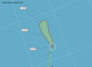
English: Central Weather Administration's forecast map of Northwest Pacific tropical storm Namtheun. |
| Date | |
| Source | https://www.cwb.gov.tw/Data/typhoon/TY_NEWS/Download_PTA_202110161800_NAMTHEUN_enus.png |
| Author | Central Weather Administration |
| Other versions |
Traditional Chinese: .png) |

.png&action=edit§ion=1)
Licensing
edit.png&action=edit§ion=2)

|
The copyright holder of this file, Central Weather Administration, allows anyone to use it for any purpose, provided that the copyright holder is properly attributed. Redistribution, derivative work, commercial use, and all other use is permitted. |
Attribution:
|
|
|
This file is licensed under the Government Website Open Information Announcement.
Information on Related Items:
|
 |
|
|
File history
Click on a date/time to view the file as it appeared at that time.
.png&dir=prev)
.png&offset=20211014140614)
.png&offset=&limit=20)
.png&offset=&limit=50)
.png&offset=&limit=100)
.png&offset=&limit=250)
.png&offset=&limit=500)
| Date/Time | Thumbnail | Dimensions | User | Comment | |
|---|---|---|---|---|---|
| current | 19:31, 16 October 2021 | | 956 × 700 (65 KB) | Cewbot (talk | contribs) | Import CWB tropical cyclone forecast map of Northwest Pacific tropical storm Namtheun: Position 161800Z at 32.7N 166.5E, Movement: N 17km/hr. Minimum pressure 998 hpa, Max sustained winds near center 20 meter per second, Gusts 28 meter per second, Radius of over 15m/s winds 80km. https://www.cwb.gov.tw/Data/typhoon/TY_NEWS/Download_PTA_202110161800_NAMTHEUN_enus.png (2021-10-16 18:00 UTC) |
| 13:31, 16 October 2021 |  | 956 × 700 (81 KB) | Cewbot (talk | contribs) | Import CWB tropical cyclone forecast map of Northwest Pacific tropical storm Namtheun: Position 161200Z at 31.8N 165.4E, Movement: NNE 21km/hr. Minimum pressure 995 hpa, Max sustained winds near center 23 meter per second, Gusts 28 meter per second, Radius of over 15m/s winds 100km. https://www.cwb.gov.tw/Data/typhoon/TY_NEWS/Download_PTA_202110161200_NAMTHEUN_enus.png (2021-10-16 12:00 UTC) | |
| 08:05, 16 October 2021 |  | 956 × 700 (84 KB) | Cewbot (talk | contribs) | Import CWB tropical cyclone forecast map of Northwest Pacific tropical storm Namtheun: Position 160600Z at 30.7N 165.2E, Movement: NNE 14km/hr. Minimum pressure 995 hpa, Max sustained winds near center 23 meter per second, Gusts 30 meter per second, Radius of over 15m/s winds 100km. https://www.cwb.gov.tw/Data/typhoon/TY_NEWS/Download_PTA_202110160600_NAMTHEUN_enus.png (2021-10-16 06:00 UTC) | |
| 02:05, 16 October 2021 |  | 956 × 700 (152 KB) | Cewbot (talk | contribs) | Import CWB tropical cyclone forecast map of Northwest Pacific tropical storm Namtheun: Position 160000Z at 29.4N 164.2E, Movement: NNE 14km/hr. Minimum pressure 995 hpa, Max sustained winds near center 23 meter per second, Gusts 30 meter per second, Radius of over 15m/s winds 100km. https://www.cwb.gov.tw/Data/typhoon/TY_NEWS/Download_PTA_202110160000_NAMTHEUN_enus.png (2021-10-16 00:00 UTC) | |
| 19:31, 15 October 2021 |  | 956 × 700 (153 KB) | Cewbot (talk | contribs) | Import CWB tropical cyclone forecast map of Northwest Pacific tropical storm Namtheun: Position 151800Z at 27.9N 162.8E, Movement: NNE 24km/hr. Minimum pressure 995 hpa, Max sustained winds near center 23 meter per second, Gusts 30 meter per second, Radius of over 15m/s winds 100km. https://www.cwb.gov.tw/Data/typhoon/TY_NEWS/Download_PTA_202110151800_NAMTHEUN_enus.png (2021-10-15 18:00 UTC) | |
| 14:05, 15 October 2021 |  | 956 × 700 (153 KB) | Cewbot (talk | contribs) | Import CWB tropical cyclone forecast map of Northwest Pacific tropical storm Namtheun: Position 151200Z at 26.8N 161.8E, Movement: NE 22km/hr. Minimum pressure 995 hpa, Max sustained winds near center 23 meter per second, Gusts 28 meter per second, Radius of over 15m/s winds 100km. https://www.cwb.gov.tw/Data/typhoon/TY_NEWS/Download_PTA_202110151200_NAMTHEUN_enus.png (2021-10-15 12:00 UTC) | |
| 08:05, 15 October 2021 |  | 956 × 700 (150 KB) | Cewbot (talk | contribs) | Import CWB tropical cyclone forecast map of Northwest Pacific tropical storm Namtheun: Position 150600Z at 26.1N 161.0E, Movement: NNE 18km/hr. Minimum pressure 992 hpa, Max sustained winds near center 23 meter per second, Gusts 30 meter per second, Radius of over 15m/s winds 100km. https://www.cwb.gov.tw/Data/typhoon/TY_NEWS/Download_PTA_202110150600_NAMTHEUN_enus.png (2021-10-15 06:00 UTC) | |
| 02:06, 15 October 2021 |  | 956 × 700 (109 KB) | Cewbot (talk | contribs) | Import CWB tropical cyclone forecast map of Northwest Pacific tropical storm Namtheun: Position 150000Z at 25.5N 159.9E, Movement: NE 15km/hr. Minimum pressure 992 hpa, Max sustained winds near center 23 meter per second, Gusts 30 meter per second, Radius of over 15m/s winds 100km. https://www.cwb.gov.tw/Data/typhoon/TY_NEWS/Download_PTA_202110150000_NAMTHEUN_enus.png (2021-10-15 00:00 UTC) | |
| 20:06, 14 October 2021 |  | 956 × 700 (159 KB) | Cewbot (talk | contribs) | Import CWB tropical cyclone forecast map of Northwest Pacific tropical storm Namtheun: Position 141800Z at 25.0N 159.3E, Movement: NE 9km/hr. Minimum pressure 995 hpa, Max sustained winds near center 20 meter per second, Gusts 28 meter per second, Radius of over 15m/s winds 100km. https://www.cwb.gov.tw/Data/typhoon/TY_NEWS/Download_PTA_202110141800_NAMTHEUN_enus.png (2021-10-14 18:00 UTC) | |
| 14:06, 14 October 2021 |  | 956 × 700 (109 KB) | Cewbot (talk | contribs) | Import CWB tropical cyclone forecast map of Northwest Pacific tropical storm Namtheun: Position 141200Z at 24.5N 157.9E, Movement: ENE 18km/hr. Minimum pressure 995 hpa, Max sustained winds near center 20 meter per second, Gusts 28 meter per second, Radius of over 15m/s winds 100km. https://www.cwb.gov.tw/Data/typhoon/TY_NEWS/Download_PTA_202110141200_NAMTHEUN_enus.png (2021-10-14 12:00 UTC) |
You cannot overwrite this file.
File usage on Commons
The following page uses this file:
.png&oldid=762459419)