File:2021 NRL EP172021 RICK infrared-gray satellite.png

Size of this preview: 600 × 600 pixels. Other resolutions: 240 × 240 pixels | 480 × 480 pixels | 768 × 768 pixels | 1,024 × 1,024 pixels | 1,400 × 1,400 pixels.
Original file (1,400 × 1,400 pixels, file size: 778 KB, MIME type: image/png)
Captions
Captions
Add a one-line explanation of what this file represents
Summary
edit
| Description |
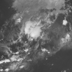
English: United States Naval Research Laboratory's infrared-gray satellite image of East Pacific RICK #500. |
| Date | |
| Source |
https://www.nrlmry.navy.mil/TC.html https://www.nrlmry.navy.mil/tcdat/tc2021/EP/EP172021/png_clean/Infrared-Gray/goes-17/20211026_055031_EP172021_abi_goes-17_Infrared-Gray_85kts_100p00_1p0.png |
| Author | United States Naval Research Laboratory |
Licensing
edit
This file is a work of a sailor or employee of the U.S. Navy, taken or made as part of that person's official duties. As a work of the U.S. federal government, it is in the public domain in the United States.
|
 | |
| This file has been identified as being free of known restrictions under copyright law, including all related and neighboring rights. | ||
File history
Click on a date/time to view the file as it appeared at that time.
| Date/Time | Thumbnail | Dimensions | User | Comment | |
|---|---|---|---|---|---|
| current | 06:06, 26 October 2021 | | 1,400 × 1,400 (778 KB) | Cewbot (talk | contribs) | Import NRL tropical cyclone infrared-gray satellite image of East Pacific RICK #500. Satellite: goes-17 (2021-10-25 23:05 UTC) |
| 05:32, 26 October 2021 |  | 1,400 × 1,400 (786 KB) | Cewbot (talk | contribs) | Import NRL tropical cyclone infrared-gray satellite image of East Pacific RICK #496. Satellite: goes-17 (2021-10-25 22:25 UTC) | |
| 05:06, 26 October 2021 |  | 1,400 × 1,400 (792 KB) | Cewbot (talk | contribs) | Import NRL tropical cyclone infrared-gray satellite image of East Pacific RICK #494. Satellite: goes-17 (2021-10-25 22:05 UTC) | |
| 04:32, 26 October 2021 |  | 1,400 × 1,400 (805 KB) | Cewbot (talk | contribs) | Import NRL tropical cyclone infrared-gray satellite image of East Pacific RICK #490. Satellite: goes-17 (2021-10-25 21:23 UTC) | |
| 04:06, 26 October 2021 |  | 1,400 × 1,400 (812 KB) | Cewbot (talk | contribs) | Import NRL tropical cyclone infrared-gray satellite image of East Pacific RICK #488. Satellite: goes-17 (2021-10-25 21:03 UTC) | |
| 03:32, 26 October 2021 |  | 1,400 × 1,400 (816 KB) | Cewbot (talk | contribs) | Import NRL tropical cyclone infrared-gray satellite image of East Pacific RICK #484. Satellite: goes-17 (2021-10-25 20:24 UTC) | |
| 03:07, 26 October 2021 |  | 1,400 × 1,400 (821 KB) | Cewbot (talk | contribs) | Import NRL tropical cyclone infrared-gray satellite image of East Pacific RICK #482. Satellite: goes-17 (2021-10-25 20:04 UTC) | |
| 02:32, 26 October 2021 |  | 1,400 × 1,400 (825 KB) | Cewbot (talk | contribs) | Import NRL tropical cyclone infrared-gray satellite image of East Pacific RICK #478. Satellite: goes-17 (2021-10-25 19:24 UTC) | |
| 02:06, 26 October 2021 |  | 1,400 × 1,400 (829 KB) | Cewbot (talk | contribs) | Import NRL tropical cyclone infrared-gray satellite image of East Pacific RICK #476. Satellite: goes-17 (2021-10-25 19:04 UTC) | |
| 01:32, 26 October 2021 |  | 1,400 × 1,400 (835 KB) | Cewbot (talk | contribs) | Import NRL tropical cyclone infrared-gray satellite image of East Pacific RICK #472. Satellite: goes-17 (2021-10-25 18:24 UTC) |
You cannot overwrite this file.
File usage on Commons
There are no pages that use this file.