File:2023 Netherlands States-Provincial election map.svg

Size of this PNG preview of this SVG file: 774 × 600 pixels. Other resolutions: 310 × 240 pixels | 620 × 480 pixels | 992 × 768 pixels | 1,280 × 992 pixels | 2,560 × 1,983 pixels | 1,815 × 1,406 pixels.
Original file (SVG file, nominally 1,815 × 1,406 pixels, file size: 2.67 MB)
Captions
Captions
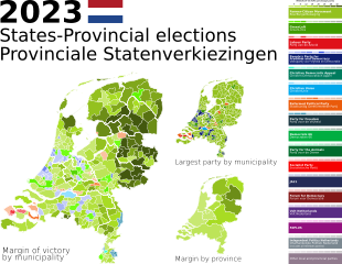
Map of the Netherlands' 2023 States-Provincial elections.
Summary
edit
| Description |
English: This is a map of the results of the 2023 Dutch provincial elections. The data was sourced from [1]
Notes on joint lists: For the GL-PvdA joint list in Zeeland, this map uses PvdA colors. For the CU-SGP joint list in North Brabant, this map uses CU colors. In the provinces where parties did not run on a joint list, this map takes the margin of the two against each other. For example, in a municipality where GL came first, PvdA came second, and BBB came third, the map takes the margin of GL from PvdA, not GL+PvdA against BBB. |
| Date | |
| Source | Own work |
| Author | Windfarmer1799 |
Licensing
edit
I, the copyright holder of this work, hereby publish it under the following license:
This file is licensed under the Creative Commons Attribution-Share Alike 4.0 International license.
- You are free:
- to share – to copy, distribute and transmit the work
- to remix – to adapt the work
- Under the following conditions:
- attribution – You must give appropriate credit, provide a link to the license, and indicate if changes were made. You may do so in any reasonable manner, but not in any way that suggests the licensor endorses you or your use.
- share alike – If you remix, transform, or build upon the material, you must distribute your contributions under the same or compatible license as the original.
File history
Click on a date/time to view the file as it appeared at that time.
| Date/Time | Thumbnail | Dimensions | User | Comment | |
|---|---|---|---|---|---|
| current | 17:23, 14 October 2023 | | 1,815 × 1,406 (2.67 MB) | Windfarmer1799 (talk | contribs) | removing seat counts and percentages as redundant and out of date |
| 02:06, 20 March 2023 |  | 2,282 × 1,406 (3.11 MB) | Windfarmer1799 (talk | contribs) | All text converted to paths. The map with true text can be found in the previous revision of this file. | |
| 02:05, 20 March 2023 |  | 2,282 × 1,406 (2.17 MB) | Windfarmer1799 (talk | contribs) | Update to reflect newly counted votes in North Holland. | |
| 18:09, 19 March 2023 |  | 2,282 × 1,406 (3.11 MB) | Windfarmer1799 (talk | contribs) | All text converted to paths. The map with embedded text can be found in the previous revision of this file. | |
| 18:07, 19 March 2023 |  | 2,282 × 1,406 (2.17 MB) | Windfarmer1799 (talk | contribs) | Uploaded own work with UploadWizard |
You cannot overwrite this file.
File usage on Commons
The following 3 pages use this file:
File usage on other wikis
The following other wikis use this file:
- Usage on en.wikipedia.org
- Usage on es.wikipedia.org
- Usage on www.wikidata.org