File:20 Jahre Mauerfall (2009).jpg

Size of this preview: 800 × 529 pixels. Other resolutions: 320 × 211 pixels | 640 × 423 pixels | 1,024 × 677 pixels | 1,280 × 846 pixels | 2,560 × 1,692 pixels | 3,582 × 2,367 pixels.
Original file (3,582 × 2,367 pixels, file size: 5.02 MB, MIME type: image/jpeg)
Captions
Captions
Add a one-line explanation of what this file represents
Summary edit
.jpg&action=edit§ion=1)
| Description |
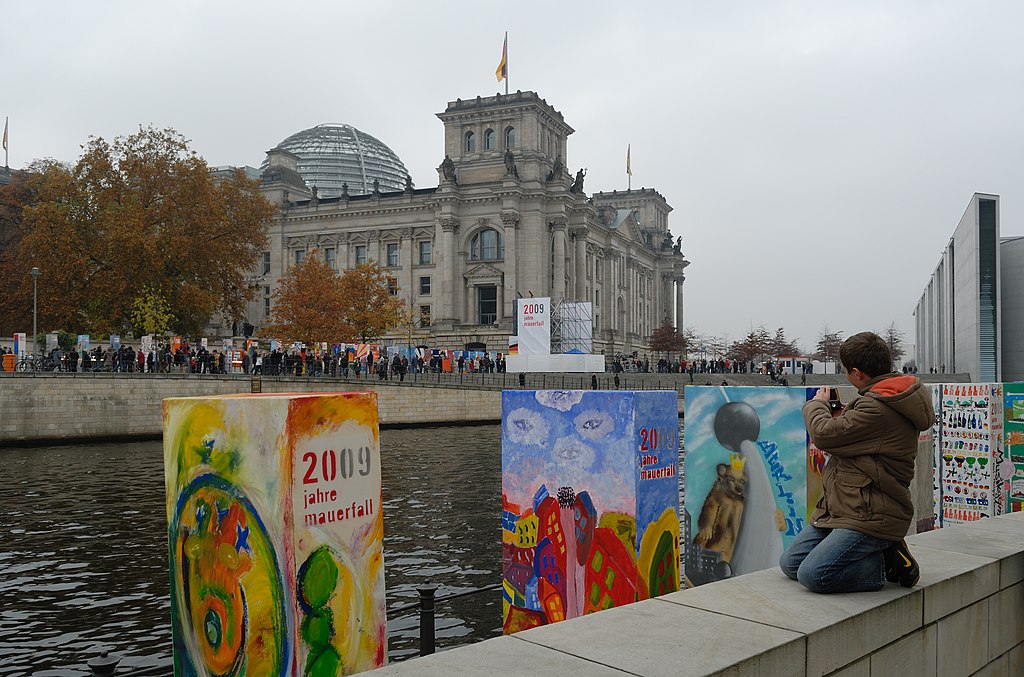
English: 20th anniversary of the Fall of the Berlin Wall. Remembering the Wall 1000 "dominos" painted by volunteers were erected (Domino Action) which fell down again in a celebration on Nov. 9, 2009. – A boy takes a photograph of a domino with the Fernsehturm and the Berlin bear. Behind the Spree the domino line continues east of Reichstag passing Brandenburg Gate up to Potsdamer Platz.
Deutsch: Die Dominoaktion feierte den 20. Jahrestag des Falls der Mauer: Freiwillige bemalten tausend Dominosteine, die in einer Veranstaltung am 9. November 2009 erneut fielen. – Hier fotografiert ein Junge einen Dominostein mit dem Fernsehturm und dem Berliner Bären. Am anderen Spreeufer setzt sich die Dominoreihe fort. Sie verläuft östlich des Reichstagsgebäudes vorbei am Brandenburger Tor bis zum Potsdamer Platz. |
| Date | |
| Source | Own work |
| Author | Jochen Teufel |
| Camera location | | View this and other nearby images on: OpenStreetMap |
|---|
.jpg¶ms=052.519556_N_0013.378556_E_globe:Earth_type:camera__&language=en)
Licensing edit
.jpg&action=edit§ion=2)
I, the copyright holder of this work, hereby publish it under the following licenses:
This file is licensed under the Creative Commons Attribution-Share Alike 3.0 Unported license.
- You are free:
- to share – to copy, distribute and transmit the work
- to remix – to adapt the work
- Under the following conditions:
- attribution – You must give appropriate credit, provide a link to the license, and indicate if changes were made. You may do so in any reasonable manner, but not in any way that suggests the licensor endorses you or your use.
- share alike – If you remix, transform, or build upon the material, you must distribute your contributions under the same or compatible license as the original.

|
Permission is granted to copy, distribute and/or modify this document under the terms of the GNU Free Documentation License, Version 1.2 or any later version published by the Free Software Foundation; with no Invariant Sections, no Front-Cover Texts, and no Back-Cover Texts. A copy of the license is included in the section entitled GNU Free Documentation License. |
You may select the license of your choice.
This image has been assessed using the Quality image guidelines and is considered a Quality image.
|
File history
Click on a date/time to view the file as it appeared at that time.
| Date/Time | Thumbnail | Dimensions | User | Comment | |
|---|---|---|---|---|---|
| current | 17:42, 1 March 2010 | | 3,582 × 2,367 (5.02 MB) | Iotatau (talk | contribs) | {{Information |Description={{en|1=20th anniversary of the Fall of the Berlin Wall. Remembering the Wall 1000 "dominos" painted by volunteers were erected ([http://www.mauerfall09.de/en/portal/9-november/ge |
You cannot overwrite this file.
File usage on Commons
The following 4 pages use this file:
File usage on other wikis
The following other wikis use this file:
- Usage on fr.wikipedia.org
- Usage on is.wikipedia.org
- Usage on sr.wikipedia.org
.jpg&oldid=822995877)