File:360° Panorama Geißspitze 2334m Rätikon 1.jpg

Size of this preview: 799 × 174 pixels. Other resolutions: 320 × 70 pixels | 640 × 140 pixels | 1,024 × 223 pixels | 1,280 × 279 pixels | 7,940 × 1,731 pixels.
Original file (7,940 × 1,731 pixels, file size: 10.85 MB, MIME type: image/jpeg)
Captions
Captions
Add a one-line explanation of what this file represents
| 360° | View in 360° panoramic viewer
|
|---|
| Description |
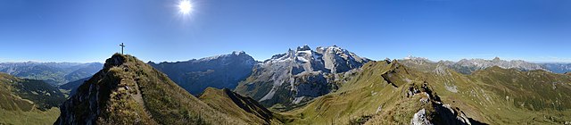
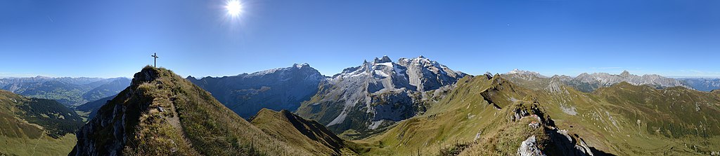
Deutsch: Die Geißspitze ist ein 2.334 Meter hoher Berg im österreichischen Bundesland Vorarlberg in der Region Montafon. Sie liegt im Rätikon oberhalb von Tschagguns. Die Bildmitte zeigt die frisch beschneiten Drei Türme und rechts den Gebirgszug der "Steinernen Wand". Der Blick ins Tal links vom Gipfelkreuz, geht über das Gauertal ins Montafon.
|
||
| Date | |||
| Source | Own work | ||
| Author |
|
||
| Permission (Reusing this file) |
I, the copyright holder of this work, hereby publish it under the following license: This file is licensed under the Creative Commons Attribution-Share Alike 3.0 Austria license.
 |
||
| Other versions |


| Camera location | | View this and other nearby images on: OpenStreetMap |
|---|
| Annotations | This image is annotated: View the annotations at Commons |
File history
Click on a date/time to view the file as it appeared at that time.
| Date/Time | Thumbnail | Dimensions | User | Comment | |
|---|---|---|---|---|---|
| current | 21:00, 1 October 2013 | 7,940 × 1,731 (10.85 MB) | Böhringer (talk | contribs) | Kleinigkeiten entfernt | |
| 20:07, 1 October 2013 | 7,940 × 1,731 (10.83 MB) | Böhringer (talk | contribs) | {{Pano360|horizon=65}} {{Information |Description= {{de|Die Geißspitze ist ein 2.334 Meter hoher Berg im österreichischen Bundesland Vorarlberg in der Region Montafon. Sie liegt im Rätikon oberhalb von [[:de:Tschagguns|Tschaggun... |
You cannot overwrite this file.
File usage on Commons
The following 2 pages use this file:
File usage on other wikis
The following other wikis use this file:
- Usage on de.wikipedia.org
- Usage on www.wikidata.org
- Usage on zh.wikipedia.org