File:43 HOT ROLL, A TWO-HIGH REVERSING MILL THAT PRODUCES THE LONGEST COPPER AND ALLOY STRIP IN THE U.S. INDUSTRY. OVERALL LENGTH OF THE RUN-OUT LINE IS 300'. - American Brass Foundry HAER NY,15-BUF,25-19.tif

Size of this JPG preview of this TIF file: 800 × 576 pixels. Other resolutions: 320 × 231 pixels | 640 × 461 pixels | 1,024 × 738 pixels | 1,280 × 922 pixels | 2,560 × 1,844 pixels | 5,000 × 3,602 pixels.
Original file (5,000 × 3,602 pixels, file size: 17.18 MB, MIME type: image/tiff)
Captions
Captions
Add a one-line explanation of what this file represents
Summary edit
| -43 HOT ROLL, A TWO-HIGH REVERSING MILL THAT PRODUCES THE LONGEST COPPER AND ALLOY STRIP IN THE U.S. INDUSTRY. OVERALL LENGTH OF THE RUN-OUT LINE IS 300'. - American Brass Foundry, 70 Sayre Street, Buffalo, Erie County, NY | ||||
|---|---|---|---|---|
| Photographer |
Lowe, Jet Related names:
|
|||
| Title |
-43 HOT ROLL, A TWO-HIGH REVERSING MILL THAT PRODUCES THE LONGEST COPPER AND ALLOY STRIP IN THE U.S. INDUSTRY. OVERALL LENGTH OF THE RUN-OUT LINE IS 300'. - American Brass Foundry, 70 Sayre Street, Buffalo, Erie County, NY |
|||
| Depicted place | New York; Erie County; Buffalo | |||
| Date | 1986 | |||
| Dimensions | 5 x 7 in. | |||
| Current location |
Library of Congress Prints and Photographs Division Washington, D.C. 20540 USA http://hdl.loc.gov/loc.pnp/pp.print |
|||
| Accession number |
HAER NY,15-BUF,25-19 |
|||
| Credit line |
|
|||
| Notes |
|
|||
| Source | https://www.loc.gov/pictures/item/ny1814.photos.351521p | |||
| Permission (Reusing this file) |
|
|||

| Object location | | View this and other nearby images on: OpenStreetMap |
|---|
File history
Click on a date/time to view the file as it appeared at that time.
| Date/Time | Thumbnail | Dimensions | User | Comment | |
|---|---|---|---|---|---|
| current | 10:43, 1 August 2014 | 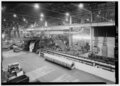 | 5,000 × 3,602 (17.18 MB) | Fæ (talk | contribs) | GWToolset: Creating mediafile for Fæ. HABS 1 Aug (2301:2600) missing |
You cannot overwrite this file.
File usage on Commons
The following 2 pages use this file:
- File:-43 HOT ROLL, A TWO-HIGH REVERSING MILL THAT PRODUCES THE LONGEST COPPER AND ALLOY STRIP IN THE U.S. INDUSTRY. OVERALL LENGTH OF THE RUN-OUT LINE IS 300'. - American Brass Foundry HAER NY,15-BUF,25-19.tif (file redirect)
- File:43 HOT ROLL, A TWO-HIGH REVERSING MILL THAT PRODUCES THE LONGEST COPPER AND ALLOY STRIP IN THE U.S. INDUSTRY. OVERALL LENGTH OF THE RUN-OUT LINE IS 300'. - American Brass Foundry HAER NY,15-BUF,25-19.tif