File:5KE-a.jpg
No higher resolution available.
5KE-a.jpg (500 × 498 pixels, file size: 97 KB, MIME type: image/jpeg)
Captions
Captions
Add a one-line explanation of what this file represents
Summary edit
| Description |
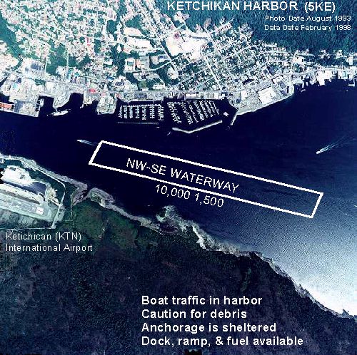
English: Annotated aerial photograph of Ketchikan Harbor Seaplane Base (FAA: 5KE) in Ketchikan, Alaska, United States |
| Date | Photo: August 1993; Data: February 1998 |
| Source |
Image: http://www.alaska.faa.gov/fai/images/SEAK/5KE-a.jpg Web site: Alaska Airport Photos and Diagrams. Archived from the original on 2007-11-14. Retrieved on 2009-10-24. |
| Author | Federal Aviation Administration, Alaska Region |
| Permission (Reusing this file) |
Public domain |
Ketchikan, Alaska 99901
| Object location | | View this and other nearby images on: OpenStreetMap |
|---|
Licensing edit
This image or file is a work of a Federal Aviation Administration employee, taken or made as part of that person's official duties. As a work of the U.S. federal government, the image is in the public domain in the United States.
|
 |
File history
Click on a date/time to view the file as it appeared at that time.
| Date/Time | Thumbnail | Dimensions | User | Comment | |
|---|---|---|---|---|---|
| current | 10:13, 10 June 2008 | | 500 × 498 (97 KB) | LeheckaG (talk | contribs) | {{Information |Description={{en|1=Ketchikan Harbor (5KE) Seaplane Base Overhead }} |Source=http://www.alaska.faa.gov/fai/images/SEAK/5KE-a.jpg |Author=Federal Aviation Administration, Alaska |Date=Photo: August 1993; Data: February 1998 |Permission= |othe |
You cannot overwrite this file.
File usage on Commons
There are no pages that use this file.
File usage on other wikis
The following other wikis use this file:
- Usage on ceb.wikipedia.org
- Usage on en.wikipedia.org
- Usage on fa.wikipedia.org
- Usage on ru.wikipedia.org
- Usage on tg.wikipedia.org
- Usage on www.wikidata.org