File:800 CE Rameshvara temple, Narasamangala Karnataka.jpg
Original file (3,300 × 5,100 pixels, file size: 3.11 MB, MIME type: image/jpeg)
Captions
Captions
Summary
edit
| Description |
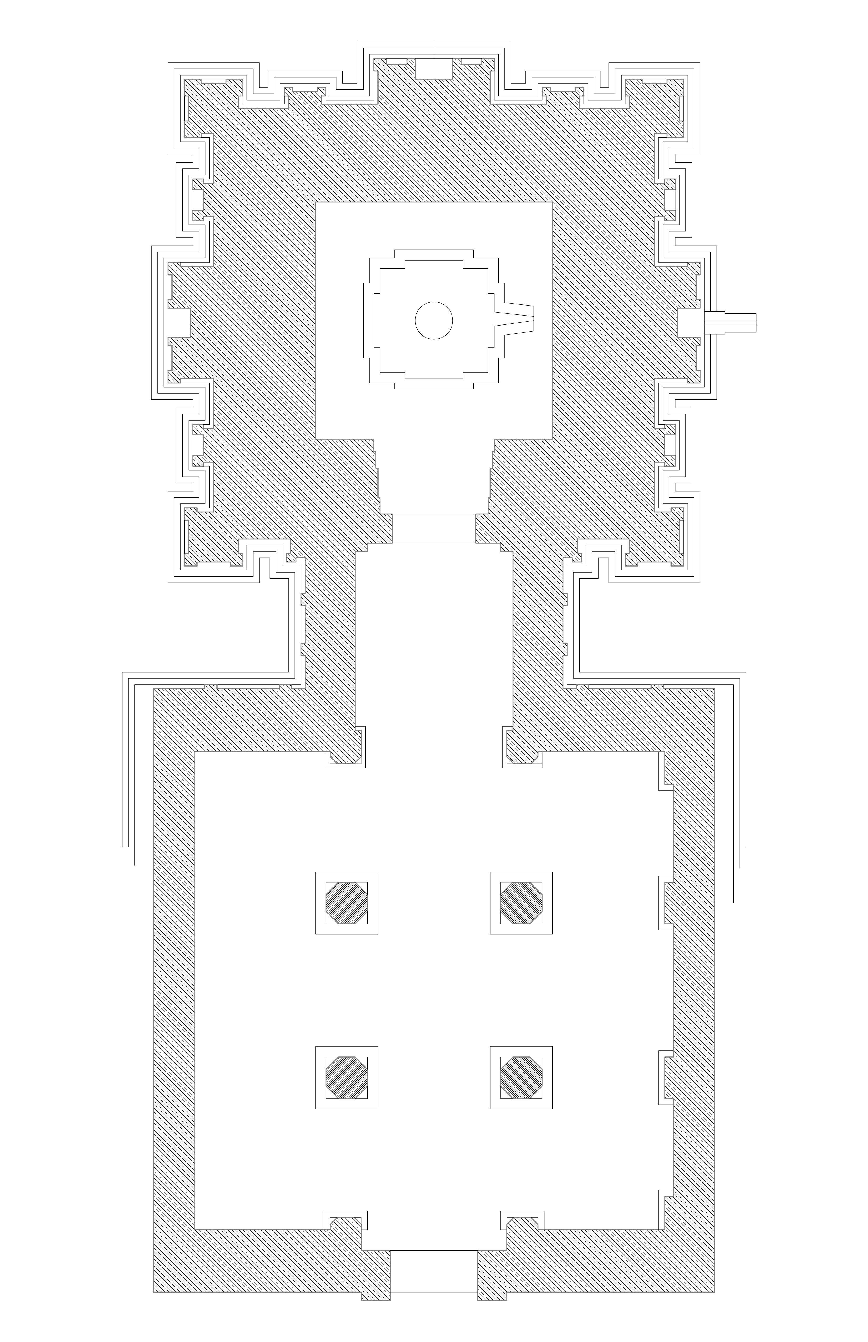
English: Location of this monument:
Narasamangala is a small, remote village in Chamarajanagar district of Karnataka, close to its border with northwest Tamil Nadu (north of Ooty). It was a major town before the 13th-century, with inscriptions already attesting to its importance by c. 800 CE through the 12th-century. When its historic importance was rediscovered in early 20th-century, the village had a large mound with numerous finely cut bricks and deliberately mutilated Hindu art ruins sticking out of the mound. On the eastern slope of this mound was the Rameshwara temple. Now also known as the Ramalingeshwara temple, the temple is called Ramanathadeva temple in the inscription slabs. It is comparable in historic importance and quality of artwork to the Ellora in Maharashtra, Dharmaraja Ratha at Mahabalipuram, and other particularly notable temples of Karnataka – Bhoganandi temple at Nandi, Kalieshvara temple in Talkad and the temples in Shravanabelagola. The temple was originally made of stone and bricks. From pillars to panels, the Rameshvara temple offers a glimpse into the high levels of artisan accomplishment by about 800 CE. The temple shows signs of deliberate damage, yet many parts are among the best preserved in south Karnataka. Of particular note are the Shiva artwork on the south face of the temple, Vishnu artwork on the west face, Shakta (Durga, Varahi, etc) artwork on the north face – once again attesting to the reverence for all three traditions of Hinduism in major temples in the first millennium. This is a JPEG format plan and architectural drawing of a historic Indian temple or monument. The relative scale and relative dimensions in this architectural drawing are close to the actual but neither exact nor complete. The plan illustrates the design and layout, but some intricate details or parts of the temple may not be shown. In cases where exact measurements were not feasible, the drawing uses best approximations and rounds the best measurements feasible. Note: Please do not overwrite this file. To modify or correct or load a new version, please upload a new separate file and link the new other version(s) to this file as recommended by wikimedia commons guidelines. |
||||
| Date | |||||
| Source | Own work | ||||
| Author | Ms Sarah Welch |
Licensing
edit
| This file is made available under the Creative Commons CC0 1.0 Universal Public Domain Dedication. | |
| The person who associated a work with this deed has dedicated the work to the public domain by waiving all of their rights to the work worldwide under copyright law, including all related and neighboring rights, to the extent allowed by law. You can copy, modify, distribute and perform the work, even for commercial purposes, all without asking permission.
|
File history
Click on a date/time to view the file as it appeared at that time.
| Date/Time | Thumbnail | Dimensions | User | Comment | |
|---|---|---|---|---|---|
| current | 23:58, 5 March 2023 | | 3,300 × 5,100 (3.11 MB) | Ms Sarah Welch (talk | contribs) | Uploaded own work with UploadWizard |
You cannot overwrite this file.
File usage on Commons
There are no pages that use this file.