File:87h038 Falls of the Ohio (7322952136).jpg

Original file (3,003 × 2,000 pixels, file size: 2.44 MB, MIME type: image/jpeg)
Captions
Captions
Summary edit
| Description87h038 Falls of the Ohio (7322952136).jpg |
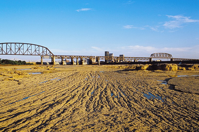
English: Looking SSE from Falls of the Ohio.
This area of outer fossil beds appears to have been grooved by flowing water and sediment. Conrail (later L&I) Bridge and downtown Louisville, Kentucky, in distance. Seen here is the limestone bedrock which forms the Falls of the Ohio. The coralline zone is the lowest layer of the Jeffersonville Limestone (named for the nearby city), which in this area is about 25 to 35 feet thick, depending on where it is measured. The coralline zone is about 8 to 11 feet thick and is named for the many species of fossil coral found in it. This limestone dates back to the middle Devonian Period, about 375 million years ago, when the continental plates were arranged much differently than today. The Falls area at that time was nearer to the equator, the bed of a shallow tropical sea, somewhat like the Bahamas today. Many of the animals in the sea had calcium carbonate shells or skeletons which settled to the bottom when they died. Together with the waste products of living animals, the remains formed a sediment which over time lithified into limestone. Much later in geological time, during the last 10,000 years, the Ohio River eroded down through glacial deposits until it reached the limestone bedrock seen at the Falls. Before the dam was built, the bedrock was exposed at low water across the entire width of the Ohio River, forming rapids about 2 miles long with a drop of about 26 feet. These rapids, known as the Falls of the Ohio, were a natural barrier to navigation and stimulated the early development of Louisville, Jeffersonville, Clarksville and New Albany. See also: Falls of the Ohio Educator's Handbook (PDF). Fossil Beds of the Falls of the Ohio (PDF). Powell, Richard L., 1970 (revised 1999). Geology of the Falls of the Ohio River: Indiana Geological Survey Circular 10. Conkin, James E., and Conkin, Barbara M., 1980. Handbook of Strata and Fossils at the Falls of the Ohio: University of Louisville Studies in Paleontology and Stratigraphy. Ohio River mile 605. Kentucky owns the river, but the Falls are accessible from Clarksville, Indiana. Aug. 1987. File # 87h038. . 35 mm E-6 slide. scanned with Plustek OpticFilm 7600i and Silverfast 8. edited with Picture Window 4 |
| Date | |
| Source | 87h038: Falls of the Ohio |
| Author | William Alden from Louisville, Kentucky, USA |
| Camera location | 38° 16′ 29.44″ N, 85° 46′ 02.75″ W | View this and other nearby images on: OpenStreetMap |
|---|
Licensing edit
- You are free:
- to share – to copy, distribute and transmit the work
- to remix – to adapt the work
- Under the following conditions:
- attribution – You must give appropriate credit, provide a link to the license, and indicate if changes were made. You may do so in any reasonable manner, but not in any way that suggests the licensor endorses you or your use.
- share alike – If you remix, transform, or build upon the material, you must distribute your contributions under the same or compatible license as the original.
| This image was originally posted to Flickr by Bill Alden at https://flickr.com/photos/70020260@N04/7322952136 (archive). It was reviewed on 27 November 2019 by FlickreviewR 2 and was confirmed to be licensed under the terms of the cc-by-sa-2.0. |
27 November 2019
File history
Click on a date/time to view the file as it appeared at that time.
| Date/Time | Thumbnail | Dimensions | User | Comment | |
|---|---|---|---|---|---|
| current | 22:07, 27 November 2019 |  | 3,003 × 2,000 (2.44 MB) | Ser Amantio di Nicolao (talk | contribs) | Transferred from Flickr via #flickr2commons |
You cannot overwrite this file.
File usage on Commons
The following page uses this file:
Metadata
This file contains additional information such as Exif metadata which may have been added by the digital camera, scanner, or software program used to create or digitize it. If the file has been modified from its original state, some details such as the timestamp may not fully reflect those of the original file. The timestamp is only as accurate as the clock in the camera, and it may be completely wrong.
| Author | William Alden III |
|---|---|
| Copyright holder | William Alden III |
| Horizontal resolution | 3,600 dpi |
| Vertical resolution | 3,600 dpi |
| Software used | SilverFast 8.0.1 r11 (May 23 2012) c8578ee 23.05 |
| Y and C positioning | Co-sited |
| Pair of black and white reference values |
|
| Exif version | 2 |
| Meaning of each component |
|
| Supported Flashpix version | 1 |
| Color space | sRGB |