File:99c039 supplement 1876 map showing Portland area (6761345045).jpg

Original file (3,396 × 2,463 pixels, file size: 2.19 MB, MIME type: image/jpeg)
Captions
Captions
Summary edit
| Description99c039 supplement 1876 map showing Portland area (6761345045).jpg |
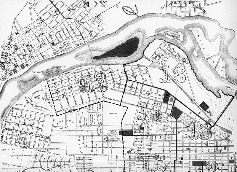
Detail of "Atlas of the City of Louisville," published in 1876 by the Louisville Abstract and Loan Association. The "old locks" refers to the original 1830 locks, with three 190x50 foot chambers. The "new locks" refers to the 1872 Scowden locks, with two 350x80 foot chambers. (The map maker erroneously drew both locks as having roughly the same width, but this map was not used for navigation.) It can be seen that the Kentucky Chute, future site of the hydroelectric plant, passed between Shippingport and Rock Island. The Middle Chute passed between Rock and Goose Islands and the Indiana Chute passed between Goose Island and the Indiana bank. The "proposed bridge" below Sand Island would be the first K&I Bridge, built in 1886. The large numbers refer to more detailed maps which I have never seen. Ohio River miles 605-609, approx. Louisville, Kentucky published 1876 |
|||
| Date | ||||
| Source | 99c039 supplement: 1876 map showing Portland area | |||
| Author | William Alden from Louisville, Kentucky, USA | |||
| Permission (Reusing this file) |
|
| Camera location | 38° 16′ 19.61″ N, 85° 47′ 44.87″ W | View this and other nearby images on: OpenStreetMap |
|---|
Licensing edit
- You are free:
- to share – to copy, distribute and transmit the work
- to remix – to adapt the work
- Under the following conditions:
- attribution – You must give appropriate credit, provide a link to the license, and indicate if changes were made. You may do so in any reasonable manner, but not in any way that suggests the licensor endorses you or your use.
- share alike – If you remix, transform, or build upon the material, you must distribute your contributions under the same or compatible license as the original.
| This image was originally posted to Flickr by Bill Alden at https://flickr.com/photos/70020260@N04/6761345045. It was reviewed on 14 April 2021 by FlickreviewR 2 and was confirmed to be licensed under the terms of the cc-by-sa-2.0. |
14 April 2021
File history
Click on a date/time to view the file as it appeared at that time.
| Date/Time | Thumbnail | Dimensions | User | Comment | |
|---|---|---|---|---|---|
| current | 04:50, 14 April 2021 |  | 3,396 × 2,463 (2.19 MB) | Geo Swan (talk | contribs) | Transferred from Flickr via #flickr2commons |
You cannot overwrite this file.
File usage on Commons
There are no pages that use this file.
Metadata
This file contains additional information such as Exif metadata which may have been added by the digital camera, scanner, or software program used to create or digitize it. If the file has been modified from its original state, some details such as the timestamp may not fully reflect those of the original file. The timestamp is only as accurate as the clock in the camera, and it may be completely wrong.
| Image title | Detail of "Atlas of the City of Louisville," published in 1876 |
|---|---|
| Author | Louisville Abstract and Loan Association |
| Copyright holder | none - in public domain |
| Horizontal resolution | 300 dpi |
| Vertical resolution | 300 dpi |
| Y and C positioning | Co-sited |
| Pair of black and white reference values |
|
| Exif version | 2 |
| Meaning of each component |
|
| Supported Flashpix version | 1 |
| Color space | sRGB |