File:A414 North Orbital Road near St Albans - geograph.org.uk - 1296481.jpg
No higher resolution available.
A414_North_Orbital_Road_near_St_Albans_-_geograph.org.uk_-_1296481.jpg (640 × 480 pixels, file size: 88 KB, MIME type: image/jpeg)
Captions
Captions
Add a one-line explanation of what this file represents
Summary
edit
| Description |
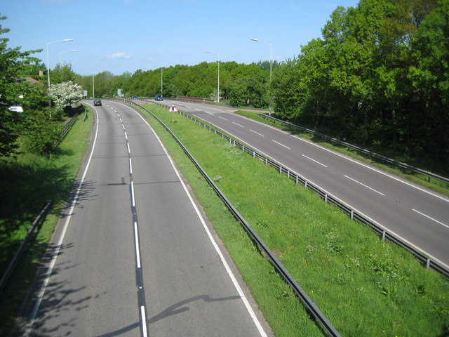
English: A414 North Orbital Road near St Albans The North Orbital Road was an early precursor to the M25 Motorway and was planned in the 1920s as a road circulating around the north side of London at about a 20 mile radius of Charing Cross. It was planned to start at Colnbrook on the A4 and, skirting past Rickmansworth, St Albans, Hatfield, Hoddesdon, and Brentwood, to terminate at Tilbury, a distance of about 75 miles. In the event only sections of it got built before the Second World War intervened. Some sections of it were then planned to be incorporated into Ringway 4, the outermost of the four London ringways that were designed, but never built, in the 1970s.
This is one of the original sections of the road to the south of St Albans, viewed from the Napsbury Lane bridge. The Ordnance Survey 6" to 1 mile map of 1925 does not show it, but the 1938 Edition does, which gives a clue at to when it was built. |
| Date | |
| Source | From geograph.org.uk |
| Author | Nigel Cox |
| Attribution (required by the license) | Nigel Cox / A414 North Orbital Road near St Albans / |
| Camera location | | View this and other nearby images on: OpenStreetMap |
|---|
_heading:292.00&language=en)
| Object location | | View this and other nearby images on: OpenStreetMap |
|---|
_heading:292.00&language=en)
Licensing
edit

|
This image was taken from the Geograph project collection. See this photograph's page on the Geograph website for the photographer's contact details. The copyright on this image is owned by Nigel Cox and is licensed for reuse under the Creative Commons Attribution-ShareAlike 2.0 license.
|
This file is licensed under the Creative Commons Attribution-Share Alike 2.0 Generic license.
Attribution: Nigel Cox
- You are free:
- to share – to copy, distribute and transmit the work
- to remix – to adapt the work
- Under the following conditions:
- attribution – You must give appropriate credit, provide a link to the license, and indicate if changes were made. You may do so in any reasonable manner, but not in any way that suggests the licensor endorses you or your use.
- share alike – If you remix, transform, or build upon the material, you must distribute your contributions under the same or compatible license as the original.
File history
Click on a date/time to view the file as it appeared at that time.
| Date/Time | Thumbnail | Dimensions | User | Comment | |
|---|---|---|---|---|---|
| current | 08:39, 27 February 2011 | | 640 × 480 (88 KB) | GeographBot (talk | contribs) | == {{int:filedesc}} == {{Information |description={{en|1=A414 North Orbital Road near St Albans The North Orbital Road was an early precursor to the M25 Motorway and was planned in the 1920s as a road circulating around the north side of London at about a |
You cannot overwrite this file.
File usage on Commons
There are no pages that use this file.