File:AMH-2503-NA Small map of Dassen Island.jpg
Size of this preview: 800 × 521 pixels. Other resolutions: 320 × 209 pixels | 640 × 417 pixels | 1,024 × 667 pixels | 1,280 × 834 pixels | 2,400 × 1,564 pixels.
Original file (2,400 × 1,564 pixels, file size: 515 KB, MIME type: image/jpeg)
Captions
Captions
Add a one-line explanation of what this file represents
Summary
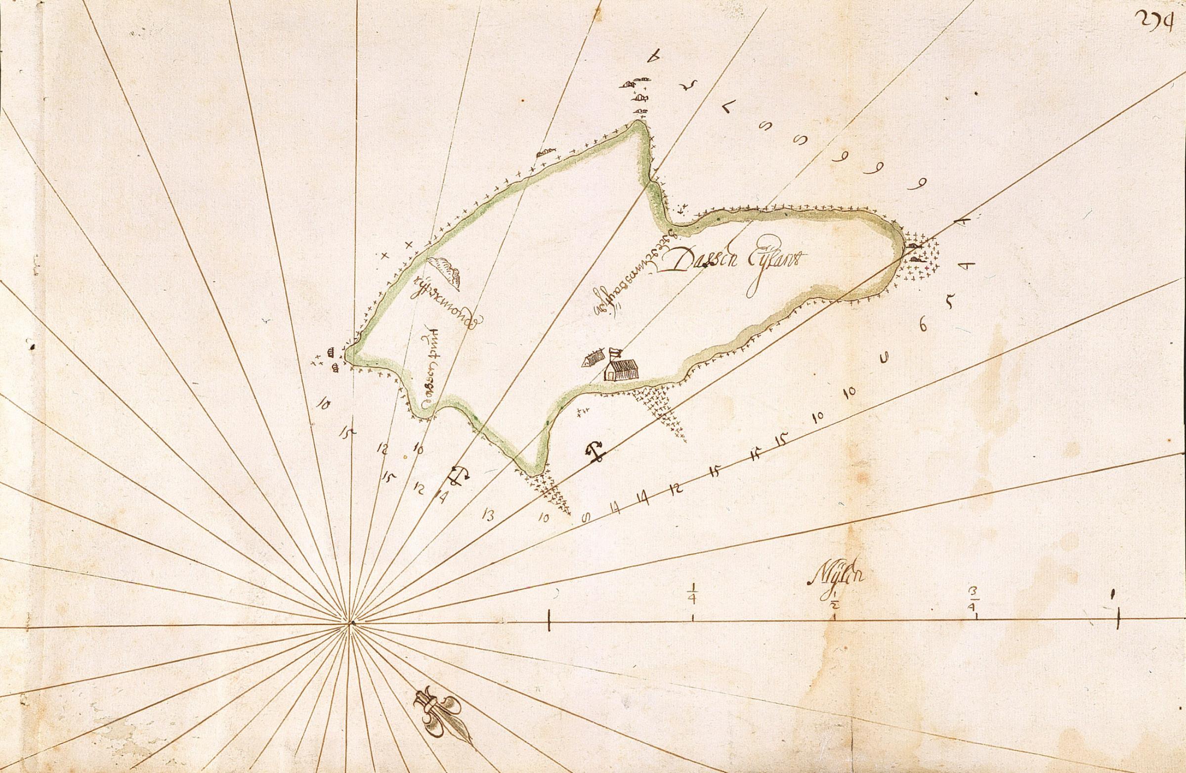
editNederlands: Kaartje van Dasseneiland
English: Small map of Dassen Island( |
||||||||||||||||||||||||
|---|---|---|---|---|---|---|---|---|---|---|---|---|---|---|---|---|---|---|---|---|---|---|---|---|
| Author |
Nederlands: Anoniem / Anonymous
English: Anoniem / Anonymous |
|||||||||||||||||||||||
| Title |
Nederlands: Kaartje van Dasseneiland
English: Small map of Dassen Island |
|||||||||||||||||||||||
| Description |
Nederlands: Titel catalogus Leupe (NA): Kaartje van het Dassen Eylant.
Notities verso: 1656 Van de Kaap 4 deel.
English: According to the Leupe (NA) catalogue, the original title reads: Kaartje van het Dassen Eylant.
Notes on reverse: 1656 Van de Kaap 4 deel. |
|||||||||||||||||||||||
| Date | circa 1656 | |||||||||||||||||||||||
| Medium |
Nederlands: ingekleurde tekening op papier
English: coloured drawing on paper |
|||||||||||||||||||||||
| Dimensions | height: 315 mm (12.40 in); width: 210 mm (8.26 in) | |||||||||||||||||||||||
| Collection |
|
|||||||||||||||||||||||
| Accession number |
NL-HaNA_4.VEL_190 (old number: VEL0190) |
|||||||||||||||||||||||
| Inscriptions |
Dassen Eijlant
|
|||||||||||||||||||||||
| Notes |
English: Subjects: chart / map / plan, house, compass / dial
Nederlands: Onderwerpen: plattegrond / kaart, huis / woonhuis, kompas / windroos
English: Post: this image is related to a VOC trading post called Dasseneiland |
|||||||||||||||||||||||
| Source/Photographer |
|
|||||||||||||||||||||||
| Permission (Reusing this file) |
|
|||||||||||||||||||||||

| Object location | | View this and other nearby images on: OpenStreetMap |
|---|
File history
Click on a date/time to view the file as it appeared at that time.
| Date/Time | Thumbnail | Dimensions | User | Comment | |
|---|---|---|---|---|---|
| current | 15:47, 10 June 2014 | | 2,400 × 1,564 (515 KB) | HuskyBot (talk | contribs) | == {{int:filedesc}} == {{Artwork |title = {{nl|1=Kaartje van Dasseneiland}} {{en|1=Small map of Dassen Island}} |description = {{nl|1=Titel catalogus Leupe (NA): ''Kaartje van het Dassen Eylant''. Notities ver... |
You cannot overwrite this file.
File usage on Commons
The following page uses this file:
File usage on other wikis
The following other wikis use this file:
- Usage on fr.wikipedia.org