File:AMH-2549-NA Plan of the Fort of Good Hope with its gardens and houses.jpg

Original file (2,063 × 2,400 pixels, file size: 750 KB, MIME type: image/jpeg)
Captions
Captions
Summary
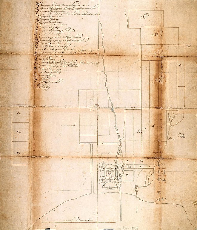
editNederlands: Plan van het fort de Goede Hoop met tuinen en woningen
English: Plan of the Fort of Good Hope with its gardens and houses( |
||||||||||||||||||||||||
|---|---|---|---|---|---|---|---|---|---|---|---|---|---|---|---|---|---|---|---|---|---|---|---|---|
| Author |
Nederlands: Pieter Potter (landmeter / kaartenmaker)
English: Pieter Potter (land surveyor / mapmaker) |
|||||||||||||||||||||||
| Title |
Nederlands: Plan van het fort de Goede Hoop met tuinen en woningen
English: Plan of the Fort of Good Hope with its gardens and houses |
|||||||||||||||||||||||
| Description |
Nederlands: Titel catalogus Leupe (NA): Nader plan als voren [enz.], hier wordt bedoeld de titel van VEL0823: Plan van 's Comps. fort de Goede Hoop, tuinen en huizingen, zoo mede het afgemeten gedeelte, tot het begin van een Stad voor de Vrylieden.
Zichtbaar is de beestenkraal achter het fort. Tevens aangeduid op deze kaart: Olifantstraat; Reijgerstraat en Heerestraat. Legenda: A-Z, a-cEnglish: The original title according to the catalogue Leupe (NA) reads: Nader plan als voren [enz.], referring to the title of VEL0823: Plan van 's Comps. fort de Goede Hoop, tuinen en huizingen, zoo mede het afgemeten gedeelte, tot het begin van een Stad voor de Vrylieden..
The corral, or kraal, for animals is behind the fort. Also indicated are the streets: Olifantstraat, Reijgerstraat en Heerestraat. Key: A-Z, a-c |
|||||||||||||||||||||||
| Date | circa 1658 | |||||||||||||||||||||||
| Medium |
Nederlands: ingekleurde tekening op papier / linnen
English: coloured drawing on paper / linen |
|||||||||||||||||||||||
| Dimensions | height: 822 mm (32.36 in); width: 941 mm (37.04 in) | |||||||||||||||||||||||
| Collection |
|
|||||||||||||||||||||||
| Accession number |
NL-HaNA_4.VEL_824 (old number: VEL0824) |
|||||||||||||||||||||||
| Inscriptions |
Compagniesfort de goede hope ende de huijsingen daarbinnen
|
|||||||||||||||||||||||
| Notes |
English: Subjects: chart / map / plan, house, building, estate / plantation, hospital / lazaret, garden / ornamental garden, fence / kraal, key
Nederlands: Onderwerpen: plattegrond / kaart, huis / woonhuis, gebouw, landerij / plantage, ziekenhuis / lazaret, tuin / siertuin, omheining / kraal, legenda
English: Fort: this image is related to a VOC fort called kasteel de Goede Hoop |
|||||||||||||||||||||||
| Source/Photographer |
|
|||||||||||||||||||||||
| Permission (Reusing this file) |
|
|||||||||||||||||||||||

| Object location | | View this and other nearby images on: OpenStreetMap |
|---|
File history
Click on a date/time to view the file as it appeared at that time.
| Date/Time | Thumbnail | Dimensions | User | Comment | |
|---|---|---|---|---|---|
| current | 15:56, 10 June 2014 | | 2,063 × 2,400 (750 KB) | HuskyBot (talk | contribs) | == {{int:filedesc}} == {{Artwork |title = {{nl|1=Plan van het fort de Goede Hoop met tuinen en woningen}} {{en|1=Plan of the Fort of Good Hope with its gardens and houses}} |description = {{nl|1=Titel catalogus... |
You cannot overwrite this file.
File usage on Commons
The following page uses this file: