File:AMH-2574-NA Map of the lodge and houses in the city of Souratte.jpg

Original file (2,400 × 1,705 pixels, file size: 522 KB, MIME type: image/jpeg)
Captions
Captions
Summary
editNederlands: Plattegrond van de loge en woningen in de stad Souratte
English: Map of the lodge and houses in the city of Souratte( |
||||||||||||||||||||||||
|---|---|---|---|---|---|---|---|---|---|---|---|---|---|---|---|---|---|---|---|---|---|---|---|---|
| Author |
Nederlands: Anoniem / Anonymous
English: Anoniem / Anonymous |
|||||||||||||||||||||||
| Title |
Nederlands: Plattegrond van de loge en woningen in de stad Souratte
English: Map of the lodge and houses in the city of Souratte |
|||||||||||||||||||||||
| Description |
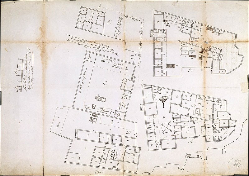
Nederlands: Titel catalogus Leupe (NA): Platte grond van 's Comps. Logies of gehuurde woningen binnen de Stad Souratte.
Legenda: nee, wel cijfers en letters aangegeven op de kaart. Plattegrond van de verschillende gebouwen A t/m E gelegen binnen de VOC loge met cijfers ter aanduiding van de indeling van de vertrekken; Met de woning van de Harkarra achter de oude loge en de woning van Sr.Wm. Leenderszn. zalr. [=zaliger?] Notities verso: nrs. 235; 3 ; potloodnr. 499 g.English: According to the Leupe catalogue (NA), the original title reads: Platte grond van 's Comps. Logies of gehuurde woningen binnen de Stad Souratte.
No key, but several numbers and letters are indicated on the chart. Floor plans of the various buildings A through E situated within the VOC lodge with figures indicating the various rooms. The map shows de Harkarra's house behind the old lodge as well as the quarters of Sr.Wm. Leenderszn. zalr. [='zaliger' ie. deceased?] Notes on reverse: nrs. 235; 3 ; potloodnr. 499 g. |
|||||||||||||||||||||||
| Date | circa 1700 | |||||||||||||||||||||||
| Medium |
Nederlands: pen op papier
English: pen on paper |
|||||||||||||||||||||||
| Dimensions | height: 53 cm (20.8 in); width: 74 cm (29.1 in) | |||||||||||||||||||||||
| Collection |
|
|||||||||||||||||||||||
| Accession number |
NL-HaNA_4.VEL_869 (old number: VEL0869) |
|||||||||||||||||||||||
| Inscriptions |
-
|
|||||||||||||||||||||||
| Notes |
English: Subjects: chart / map / plan, house, building, garden / ornamental garden, warehouse, menagerie / stable
Nederlands: Onderwerpen: plattegrond / kaart, huis / woonhuis, gebouw, tuin / siertuin, pakhuis, menagerie / stal
English: Post: this image is related to a VOC trading post called Surat |
|||||||||||||||||||||||
| Source/Photographer |
|
|||||||||||||||||||||||
| Permission (Reusing this file) |
|
|||||||||||||||||||||||

| Object location | | View this and other nearby images on: OpenStreetMap |
|---|
File history
Click on a date/time to view the file as it appeared at that time.
| Date/Time | Thumbnail | Dimensions | User | Comment | |
|---|---|---|---|---|---|
| current | 15:58, 10 June 2014 | | 2,400 × 1,705 (522 KB) | HuskyBot (talk | contribs) | == {{int:filedesc}} == {{Artwork |title = {{nl|1=Plattegrond van de loge en woningen in de stad Souratte}} {{en|1=Map of the lodge and houses in the city of Souratte}} |description = {{nl|1=Titel catalogus Leup... |
You cannot overwrite this file.
File usage on Commons
The following page uses this file: