File:AMH-2590-NA Representation of the siege of Cochin in 1663.jpg

Original file (2,400 × 1,140 pixels, file size: 439 KB, MIME type: image/jpeg)
Captions
Captions
Summary
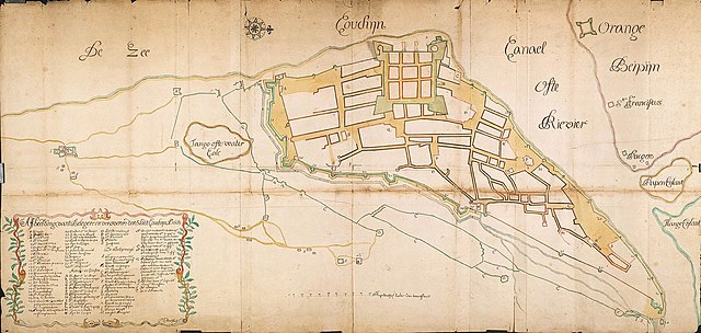
editNederlands: Afbeelding van de belegering van Cochin in 1663
English: Representation of the siege of Cochin in 1663( |
||||||||||||||||||||||||
|---|---|---|---|---|---|---|---|---|---|---|---|---|---|---|---|---|---|---|---|---|---|---|---|---|
| Author |
Nederlands: M.E. Proot (landmeter / kaartenmaker)
English: M.E. Proot (land surveyor / mapmaker) |
|||||||||||||||||||||||
| Title |
Nederlands: Afbeelding van de belegering van Cochin in 1663
English: Representation of the siege of Cochin in 1663 |
|||||||||||||||||||||||
| Description |
Nederlands: Titel catalogus Leupe (NA): Affbeelding van 't Belegeren en Veroveren der Stadt Couchyn. Aø. 1663, onder het bevel van Ryckloff van Goens.
Legenda: 1-36; A-S; A-U Belegering en verovering van Cochin 1663, onder het bevel van Ryckloff van Goens. Topografische namen vermeld op deze kaart: Orange, Beipyn, Papen Eijlant.English: According to catalogue Leupe (NA) the original title reads: Affbeelding van 't Belegeren en Veroveren der Stadt Couchyn. Aø. 1663, onder het bevel van Ryckloff van Goens.
Key: 1-36; A-S; A-U Siege and capture of Cochin in 1663, under the command of Ryckloff van Goens. Topographical names mentioned: Orange, Beipyn, Papen Eijlant. |
|||||||||||||||||||||||
| Date | 1663 | |||||||||||||||||||||||
| Medium |
Nederlands: ingekleurde tekening op papier
English: coloured drawing on paper |
|||||||||||||||||||||||
| Dimensions | height: 149 cm (58.6 in); width: 71 cm (27.9 in) | |||||||||||||||||||||||
| Collection |
|
|||||||||||||||||||||||
| Accession number |
NL-HaNA_4.VEL_894 (old number: VEL0894) |
|||||||||||||||||||||||
| Inscriptions |
Affbeelding van 't Belegeren en Veroveren der Stadt Couchyn. Aø. 1663
author: ME Proot fecit |
|||||||||||||||||||||||
| Notes |
English: Subjects: chart / map / plan, fortification, battle / taking / war (fight), warehouse, shipyard, monastery / seminary, powder magazine / powder mill, key, banderole / cartouche / ornamentation, tanck / well / watering hole
Nederlands: Onderwerpen: plattegrond / kaart, vesting, veldslag / oorlog (strijd) / inname, pakhuis, scheeps- / timmerwerf, klooster / seminarie, kruithuis / kruitmolen, legenda, banderol / cartouche / versiering, tanck / waterplaats / put
English: Post: this image is related to a VOC trading post called Cochin |
|||||||||||||||||||||||
| Source/Photographer |
|
|||||||||||||||||||||||
| Permission (Reusing this file) |
|
|||||||||||||||||||||||

| Object location | | View this and other nearby images on: OpenStreetMap |
|---|
File history
Click on a date/time to view the file as it appeared at that time.
| Date/Time | Thumbnail | Dimensions | User | Comment | |
|---|---|---|---|---|---|
| current | 16:04, 10 June 2014 | | 2,400 × 1,140 (439 KB) | HuskyBot (talk | contribs) | == {{int:filedesc}} == {{Artwork |title = {{nl|1=Afbeelding van de belegering van Cochin in 1663}} {{en|1=Representation of the siege of Cochin in 1663}} |description = {{nl|1=Titel catalogus Leupe (NA): ''Affb... |
You cannot overwrite this file.
File usage on Commons
The following page uses this file:
File usage on other wikis
The following other wikis use this file:
- Usage on nl.wikipedia.org