File:AMH-4211-NA Map of Mature.jpg

Original file (1,550 × 2,400 pixels, file size: 428 KB, MIME type: image/jpeg)
Captions
Captions
Summary edit
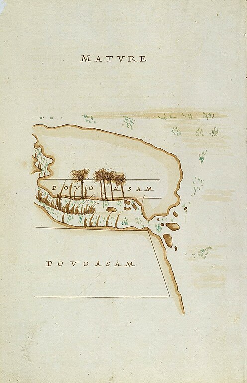
Nederlands: Plattegrond van Mature
English: Map of Mature( |
||||||||||||||||||||||||
|---|---|---|---|---|---|---|---|---|---|---|---|---|---|---|---|---|---|---|---|---|---|---|---|---|
| Author |
Nederlands: Anoniem / Anonymous (opdrachtgever), Constantio de Sa
English: Anoniem / Anonymous (patron), Constantio de Sa |
|||||||||||||||||||||||
| Title |
Nederlands: Plattegrond van Mature
English: Map of Mature |
|||||||||||||||||||||||
| Description |
Nederlands: Titel catalogus Leupe (NA): Beschryving ende Caarten van den eylande Ceylon.
Bij deze kaart behoren de kaarten uit de serie VEL0928(1)-(24). Bijschrift catalogus Leupe: De [bijbehorende] beschrijving is in het Neder-duitsch. Het origineel was op last van den Koning van Portugal, door den Generaal van Ceilon in 1606 geschreven. De naam van den vertaler der Hollandsche tekst is onbekend. Bijschrift catalogus Leupe: Facsimile met inleiding E. Reimers NA bibliotheek 196 E4 / [voorin:] volgens aantekening verkregen door ruiling met de Koninklijke Bibliotheek. Zie E. Reimers, 'Selections from the Dutch Records of the Ceylon Government, no. 2, Constantine de Sa's Maps and Plans of Ceylon (1624-1628), with an introduction, transcripts, notes and translations', Government Archivist (Colombo 1929). Hij schrijft de kaarten en de originele Portugese beschrijving toe aan Constantine de Sa en Noronha, kapitein-generaal van Ceylon van 1618 tot 1620 en 1623 tot 1630. Het geheel is ombonden met een perkamenten omslag.English: According to the Leupe catalogue (NA), the original title reads: Beschryving ende Caarten van den eylande Ceylon.
This chart is part of the series VEL0928(1)-(24). Notes in the Leupe catalogue: De [accompanying] beschrijving is in het Neder-duitsch. Het origineel was op last van den Koning van Portugal, door den Generaal van Ceilon in 1606 geschreven. De naam van den vertaler der Hollandsche tekst is onbekend. Caption in the Leupe catalogue: Facsimile met inleiding E. Reimers NA bibliotheek 196 E4 / [at front:] volgens aantekening verkregen door ruiling met de Koninklijke Bibliotheek. See E. Reimers, 'Selections from the Dutch Records of the Ceylon Government, no. 2, Constantine de Sa's Maps and Plans of Ceylon (1624-1628), with an introduction, transcripts, notes and translations', Government Archivist (Colombo 1929). Reimers states that the maps are made between 1624 and 1628. The original maps, as well as the original Portuguese descriptions are made by Constantine de Sa en Noronha, captain-general of Ceylon from 1618 to 1620 and 1623 to 1630. The charts are bound in a parchment cover. |
|||||||||||||||||||||||
| Date | between 1624 and 1628 | |||||||||||||||||||||||
| Medium |
Nederlands: ingekleurde tekening op papier
English: coloured drawing on paper |
|||||||||||||||||||||||
| Dimensions | height: 21 cm (8.2 in); width: 32 cm (12.5 in) | |||||||||||||||||||||||
| Collection |
|
|||||||||||||||||||||||
| Accession number |
NL-HaNA_4.VEL_928 (old number: VEL0928(15)) |
|||||||||||||||||||||||
| Inscriptions |
Mature
|
|||||||||||||||||||||||
| Notes |
English: Subjects: chart / map / plan, survey / view
Nederlands: Onderwerpen: plattegrond / kaart, overzicht / aanzicht
English: Post: this image is related to a VOC trading post called Matara |
|||||||||||||||||||||||
| Source/Photographer |
|
|||||||||||||||||||||||
| Permission (Reusing this file) |
|
|||||||||||||||||||||||

| Object location | | View this and other nearby images on: OpenStreetMap |
|---|
File history
Click on a date/time to view the file as it appeared at that time.
| Date/Time | Thumbnail | Dimensions | User | Comment | |
|---|---|---|---|---|---|
| current | 16:20, 10 June 2014 | | 1,550 × 2,400 (428 KB) | HuskyBot (talk | contribs) | == {{int:filedesc}} == {{Artwork |title = {{nl|1=Plattegrond van Mature}} {{en|1=Map of Mature}} |description = {{nl|1=Titel catalogus Leupe (NA): ''Beschryving ende Caarten van den eylande Ceylon''. Bij deze... |
You cannot overwrite this file.
File usage on Commons
The following page uses this file: